Wednesday, January 29, 2025

Watery flats

The Campbell River is a short one, as rivers go, with just a bit over 8 km. from its starting point at John Hart Lake to the estuary. Along most of those 8 km., it cuts through the hills in a deep, narrow, winding canyon. Nearer the estuary end, the ground flattens out, but retains the steep hill on the north side. I drove, then hiked, up the lower end of this hill to find afternoon sunlight.

Heading up. The river is down on my right. On the left, the hill continues its climb. The afternoon sun, now low in the sky, paints tree trunk shadows on the road.

For most of the way, the view is obscured by forest, but near the parking spot, they've cleared it away to put in Hydro lines and a pipe from the pump house up the hill. (Pipes from the old pump house lead to or from the Duncan Bay generating station, through ancient wood pipes.)

View down the slope from my road. Water pipe and power lines lead to the river.

The water below is a wetland, a slough. The river feeds it, but the water here is barely moving. The river runs on the far side of the first forested area, in that dark valley beyond.

Zooming in. The Canyonview trail leads down the flats on this side of the river before climbing to above Elk Falls. A side trail goes nowhere.

Google maps, satellite view, shows the layout of these wetlands and trails. I've lightened it up a bit. The yellow star is my viewing point.

Campbell River is the greyish stream cutting off the lower left corner.

I've walked on these lower trails on this side of the river; water everywhere, on both sides of the trail. Little creeklets, pools, or just soggy mud until the trail starts to climb into drier terrain.

~~~~~~~~~~~~
El Rio Campbell es un rio corto, corriendo poco más de 8 kilómetros desde su principio en el Lago John Hart hasta donde sale al estrecho Georgia al final del estuario. Por la mayor parte de esta distancia, corta su camino entre los cerros, serpenteando en un desfiladero angosto, muy hondo. Acercándose al estuario, el terreno se aplana, pero retiene la elevación abrupta en el banco del norte. Subí este pendiente, primero en el coche, luego a pie, buscando la luz del sol, ya inclinándose hacia el horizonte.
  1. Mi camino. El rio queda allá abajo en el lado derecho; a la izquierda, el cerro sigue subiendo. El sol pinta las sombras de los árboles sin hojas sobre el camino.
  2. El bosque limita la vista a lo largo del camino, pero en este lugar, han cortado el bosque para instalar cables eléctricos y tubería que baja desde el estación de bombeo en el cerro. (Los tubos se dirigen hasta Duncan Bay, en donde el agua corre por esos tubos de madera que antes se usaban.) Desde este punto, los cables y el tube van hacia la instalación de BCHydro que apenas se ve en la foto.
    El agua que se ve es un pantano. El rio lo alimenta, pero el agua apenas se mueve. El rio corre atrás del primer grupo de árboles, en ese valle oscuro más adelante.
  3. Zoom. El sendero Canyonview (Vista del Desfiladero) cruza el terreno plano aquí antes de subir hacia las cataratas. Un senderito ocasional no va a ninguna parte.
  4. En Google Maps, se ven estos terrenos acuáticos y algunos de los senderos. La estrella amarilla muestra donde yo estaba parada. El rio corta el mapa en la esquina inferior a la izquierda. 
He caminado en estos senderos de este lado del rio. Hay agua por todas partes, de ambos lados del camino; riachuelos, lagunitas, o lodo empapado, hasta que la ruta empieza a subir hacia terreno seco, camino a las cataratas.


Monday, January 27, 2025

Catching a few rays

I climbed a hill, well out of the shadows of the valley. And caught the afternoon sun picking out highlights on the moss.

Sporophites with reddish tips on a mossy mound of roadside gravel.

Glowing top on a lump of stones and cement.

~~~~~~~~~~~~~~~~~~~

Subí por un camino que me llevó por encima de las sombras del valle. Allí, donde les llegaban los rayos del sol del atardecer, los musgos brillaban como si tuvieran luces interiores.

  1. Aquí elevan sus esporofitos sobre tallos verdes, adornando un montón de grava y desperdicios de la construcción del camino.
  2. Estos crecen en una masa de cemento mezclado con piedras.

Ubiquitous

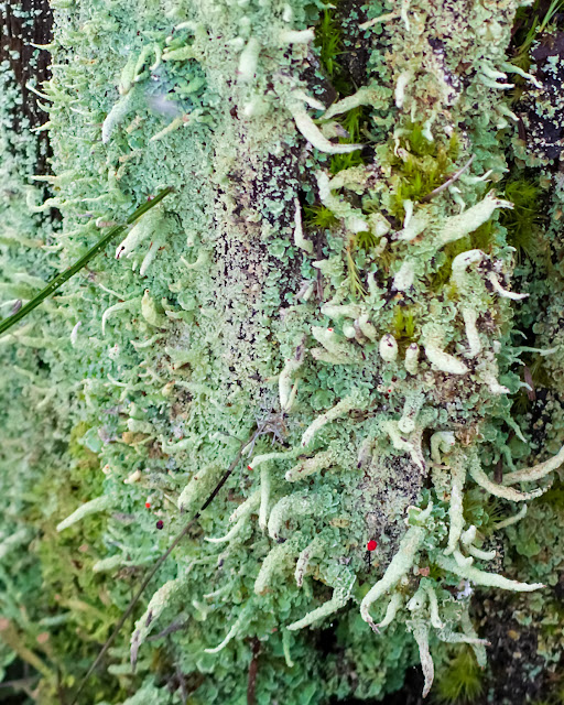
In some areas, every old bit of log or stump or even discarded wood gets covered in these tiny Cladonia sp. lichens. In the mini-forest at Oyster Bay, it's always damp, even in mid-summer; everything near or on the ground is covered in mushrooms, mosses, lichens, and sometimes slime molds. These lichens are growing near the edge of the woods, where some sunlight reaches them; the camera appreciates that.

On a burnt log. Probably lipstick lichen, Cladonia macilenta, with a mix of pixie cup lichens; these have tiny brown fruiting bodies (apothecia).

Tall clubs (podetia) with red fruiting bodies at the tips.

The tiny scales (squamules) are the first to appear, covering the wood before the fertile clubs show up.

~~~~~~~~~~~~~
En algunos sitios, cada tocón viejo, cada tronco tirado, aun cada pedazo de madera abandonado termina cubierto de estos líquenes, de varias especies de Cladonia. El bosquecito de Oyster Bay se mantiene húmedo todo el año, hasta en los dias de calor, y el suelo y la madera vieja están completamente cubiertos de hongos, musgos, líquenes, y hasta mohos mucilaginosos. Estos crecen cerca del margen exterior del bosque, donde les llega a tocar la luz, cosa que las cámaras aprecian.
  1. En un tronco quemado. Son líquenes Cladonia macilenta, el liquen "lapiz labial", compartiendo el sitio con otros del mismo género, estos de los llamados "copa de hadas"; tienen en el borde de las copas pequeños cuerpos fructíferos color café (apotecios).
  2. C. macilenta forma estructuras altas llamadas podecios; en la punta llevan los apotecios rojos.
  3. Las escamas a la base son lo primero en aparecer, cubriendo la madera antes de que se levanten los podecios.


Sunday, January 26, 2025

Mud lovers

Back to more local wanderings; a couple of photos of distant birds in Oyster Bay, those birds that to the naked eye squinting from the closest vantage point, on the dike overlooking the inner circle of the bay, are just tiny black shapes against silvery water. Or silvery mud; those will be peeps, also evident because they are all running, all the time, barely pausing to take a quick peck at the mud underfoot. The camera works better than binoculars; in the photos, the birds aren't moving, although they may be standing on their heads.

Wigeons, calmly paddling along, one eating seaweed. The males have the showy green stripe on the head. Pintails, mostly head down, tails up, beaks foraging in the mud below, males with the creamy bellies, females bedecked in patches of brown and cream. The water here is only a few inches deep.

Sandpipers, probably semipalmated. This was about 1/4 of the flock running along where the water turns to mud.

~~~~~~~~~~~~
Regresando a sitios más cerca de casa: aquí hay dos fotos de pájaros en la distancia, en Oyster Bay; esos pájaros que a mis ojos sin ayuda, viéndolos desde donde más me puedo acercar, encima del dique que bordea el círculo interior de la bahía, esos pájaros que parecen nada más que formas pequeñitas negras sobre el agua plateada. O sobre el lodo, también plateado; esos serán correlimos, creo, con más razón porque nunca dejan de correr; hasta para comer pican rápidamente en el lodo, entre paso y paso. 

La cámara me sirve mejor que los binoculares; en las fotos, los pájaros no se mueven, aunque a veces están parados de cabeza.
  1. Silbones, nadando tranquilamente; una está comiendo algas marinas. Los machos tienen la raya verde en la cabeza. Los otros patos son ánades rabudos, Anas acuta; casi todos con las colas en alto, los picos explorando el lodo al fondo. Los machos tienen el abdomen gris claro, y las hembras llevan un diseño de parches cafés sobre crema. El agua en este lugar tiene apenas unos pocos centímetros de profundidad.
  2. Correlimos, probablemente Calidris pusilla. Esto era aproximadamente un cuarto de la bandada que corrían a lo largo de la orilla, donde el agua se vuelve lodo.


Friday, January 24, 2025

Rocks again. Just because.

I don't know what to say about these photos, except that I love rocks. Their textures, their shapes, their colours, their slowness; the reminder that this moment passes in an infinitesimal flash to the rocks, in their long, patient dance through the millennia.

These sit today beside the flooded valley that forms Buttle Lake.

The green on the rock face is moss; the yellow may be lichen or pyrite.
From BCGS..., about rock formations a bit further down the road:   There the rocks lie horizontally and are stained with yellow and brown iron oxides derived from the weathering of the mineral pyrite (iron sulphide better known as fool's gold).
How thin a skin our forests (and we) live on!

Pillow lava. I've looked at this pile before. Never get tired of it.

Not exactly pillows to sleep on.
Quoted from earlier posts:
In brief, 
Molten lava commonly erupts from cracks and fissures in the earth's crust onto the ocean floor. Each pillow is formed by lava which squirted forward in front of an advancing, submarine lava flow, like toothpaste from a toothpaste tube. As the lava contacts the colder water it forms a tough crust, like a loaf of bread. However, the molten interior of each pillow makes it relatively plastic and pillows therefore tend to take on weird shapes as they settle and pile up on the ocean floor.(BCGS_IC1995-07)
And from Google Street View:

The pillows continue down to the road. (And underneath it, I'm sure.)

~~~~~~~~~~~~~
No sé que decir acerca de estas fotos, aparte de que me encantan las rocas. Sus colores, sus texturas, sus formas, su lentitud; pensar que este momento presente pasa, para las rocas, en un parpadeo infinitesimal en su baile solemne al son de los milenios.

Estas peñas esperan al lado del valle inundado que ahora forma el lago Buttle.
  1. Lo verde en la faz de la roca es musgo; lo amarillo puede ser líquenes o tal vez piritas de hierro. 
  2. ¡Qué delgada es la capa de suelo donde se establecen nuestros bosques (y nosotros mismos)!
  3. He mirado antes este montón de lava acojinada. Nunca me aburre.
  4. Viéndolo más de cerca.
  5. Los cojines siguen hasta el camino, y debajo del camino también, estoy segura.
De BCGS..., acerca de estructuras rocosas un poco más adelante en este camino: "Allí las rocas descansan horizontalmente y están manchadas con óxidos de hierro amarillos y cafés, derivados del efecto de la intemperie sobre el mineral pirita (sulfuros de hierro, más bien conocidos como "Oro de Tontos").
"Lava fundida sale de grietas y fisuras en la corteza terrestre, emergiendo en el fondo del mar. Cada almohada se forma de lava que se proyecta en frente de un flujo submarino de lava que se exprime como pasta dental de un tubo. Cuando la lava se pone en contacto con el agua fría, se endurece formando una corteza fuerte, como la de una barra de pan. Sin embargo, la parte interior de cada almohada, todavía en estado líquido, la mantiene flexible, y las almohadas (o cojines) adquieren formas extrañas mientras se acumulan una sobre otra en el fondo del agua." (BCGS_IC-19955-07)


Thursday, January 23, 2025

Looming rock face, and a question

 Beside Buttle Lake, I stopped to look at a mass of pillow lava. Walking  back to the car, I was facing this cutaway slab of streaky, brown rock atop the cliff face.

And the mountain goes on up and up and up.

Zooming in on the slab itself.

Back home (why do I never see these details when I'm there and could maybe get a bit closer?) I saw these additions to the rock face:

Do you see them? Pegs set into the rock itself, each one anchored with a square plate.

Cropped. One of those pegs has ropes attached.

What was that? I Googled "rock climbing equipment" and found nothing like these. I "drove" on Google street view up and down that stretch of highway, looking for more, but not finding any. Would they be leftovers from the rock-shaping crew cutting out a flat spot for the road?

From that Google street view; here's the same rock face.

Facing north.

Facing south. The pillow lava lump is the next rock down the road.

I guess this could count as a Skywatch post.

~~~~~~~~~~~~~
En la orilla del lago Buttle, me detuve para mirar una masa de lavas acojinadas en el acantilado. Regresando al coche, veía este peñasco; rocas cortadas, un poco inclinado hacia el lago, con manchas de color café con leche.
  1. Perspectiva, desde el camino.
  2. Mirando esa cara cortada.
  3. Y en casa (y ¿porqué será que nunca veo estos detalles cuando estoy allí en el terreno, cuando me podría acercar para verlos mejor?) en la foto descubrí estas estacas clavadas en la roca, cada una con su placa en la base.
  4. Un corte de la foto previa. Una de las estacas lleva atada una cuerda. ¿Qué son estos? Busqué equipaje para alpinistas en Google, pero no vi nada parecido. "Manejé" en Google Street View por una buena distancia alrededor de este sitio, pero no vi otras estacas. ¿Serían, acaso, equipo abandonado por los que cortaron la roca para hacer el camino?
  5. De Google Street View, este es el mismo peñasco. Esta vista, mirando hacia el norte.
  6. Y mirando hacia el sur. Adelantito se ve la masa de lava acojinada.
Parece que esto podría llamarse un post de Skywatch


Monday, January 20, 2025

Cliff, non-conformist

This was strange. Unexpected and confusing.

The sun was shining; where you stood in its light, you could feel the gentle heat. Otherwise, along the edges of the lakes (Upper Campbell and Buttle) the temperature was near freezing. In spots, where the shadows hadn't seen sunshine all day, a light coating of frost or sometimes snow dusted the ground.

Along the upper end of Upper Campbell Lake and the bottom of Buttle Lake, the highway follows the east shore, heading almost directly south. This is an area of high, stony cliffs, facing west here; the afternoon sun hits them full on, even in winter.

One of these cliff faces, just one, was producing ice. It coated the vegetation in the shallow ditch beside the road. Above, the rock was clear, but wet; isolated drips fell onto the frozen plants below, probably from melting ice farther up. Moss and plants closer to the rock were untouched, ice-free. 

This was the only icy spot. It was in a bad spot for parking; the road was narrow, without a shoulder, and trucks could be expected to barrel around the curve at any moment. The nearest pullout was over a kilometre away in both directions. So I drove on, then back, then back again, looking for more ice. There was none, and I finally eased the car into a spot between guard posts, too close to the drop off for comfort, but it was the best I could manage.

And the icicles weren't following the rules. Some hung directly down, as gravity demands; but others hung at strange angles, up to a 30° angle off the vertical. Why?

See:

Ferns in ice. The moss is ice-free.

Ice-covered  branches.

Insane icicles.

Another fern. Ice coats one hanging vine; the others, on the right, are ice-free. Go figure.

Rose hips in ghostly shrouds.

And all the way to the middle of Buttle Lake, there was not a spot of ice on any of the rock faces. Or on the ground below them. Just on this one, with its own personal microclimate.

~~~~~~~~~~~

Esto era algo extraño, inesperado.

Era una tarde asoleada; se te detenías donde la luz del sol te llegaba, sentías un calor suave. Aparte de eso, en las orillas de los lagos Upper Campbell y Buttle, la temperatura andaba cerca de 0°C. En sitios en sombra, donde la luz no había tocado en todo el dia, el suelo llevaba una leve capa de nieve o de escarcha.

Desde el centro del lago Upper Campbell, hasta el centro del lago Buttle, la carretera sigue la orilla occidental, dirigiéndose hacia el sur. En este rumbo, el  agua llega hasta el pie de peñascos altos, con sus caras hacia el oeste; el sol de la tarde les pega directamente, aun en invierno.

Uno de estas pilas de piedra producía hielo. Uno solamente. El hielo cubría las hierbas que crecen en la zanjita al lado de la carretera. Arriba, la roca estaba mojada, pero sin hielo. De allí, gotitas aisladas de agua, probablemente producidas por hielo que se descongelaba, salpicaban las plantas congeladas. El musgo que cubre la faz de la roca, y algunas plantas más protegidas se quedaban sin hielo.

Este era el único lugar con hielo. Era un sitio no apropriado para estacionarme; la carretera es angosta, sin acotamiento, y en cualquier momento se podría esperar algún camión minero manejado a la máxima velocidad permitida. El primer sitio donde se había proveído un espacio para permitir el paso estaba a más de un kilómetro en ambas direcciones. Así que seguí adelante, di vuelta cuando pude, pasé por enfrente, y volví a pasar. Esto, sin ver hielo en ningún otro sitio. Por fin, me arrimé lo más que pude, estacionando el coche en el mero borde de la caída al agua. No muy seguro, pero, ni modo.

Y los carámbanos no obedecían las reglas. Algunos colgaban apuntando directamente hacia el suelo, como exige la gravedad, pero otros apuntaba en varias direcciones, hasta a unos 30° de lo vertical. ¿Porqué?

Fotos:

  1. Helechos cubiertos de hielo, y musgos sin hielo, en la faz de la roca.
  2. Ramitas completamente cubiertas.
  3. Carámbanos locos.
  4. Otro helecho. El hielo cubre por completo una de las ramas colgantes; otras, al lado derecho, quedaron completamente libres.
  5. Escaramujos (rojos) en sudarios de fantasmas.
Y en todo el camino, desde aquí hasta la mitad del lago Buttle, no hubo ni un solo pedazo de hielo en ninguna de las rocas. Solamente en este sitio, con su microclima muy personal.

Sunday, January 19, 2025

Where the road takes me

The sky was blue, that clear blue that we get on chilly days. The highway caught me; each curve unveiled a new work of art. I ended up on the shore of Buttle Lake, looking at cliff faces.

Along the way:

Nearly there. A straight stretch, for a change. Taken through the dusty windshield.

A narrow, sinuous bit of flat ground; that's the road. Everything else stands on end.

Trees on the cliffs, leaning in for protection from the wind.

Upper Campbell Lake. I've taken many photos from this spot; the light is different every time. The mountain in the centre is Elkhorn Mountain.

Ice photos next, I think.

A Skywatch post.

~~~~~~~~~~~~~
El cielo estaba azul, ese azul clarísimo que se ve cuando la temperatura anda cerca de 0 grados. La carretera me llamaba; cada curva revelaba un paisaje nuevo. Al fin, me encontré al lado del lago Buttle, mirando peñascos.
  1. Un tramo de carretera sin curvas. No hay muchos de estos. La foto la saqué por medio del parabrisas, lleno de polvo.
  2. Carretera normal: un hilo angosto de tierra plana serpenteando al pie de las peñas.
  3. Allá arriba, estos árboles se inclinan hacia la protección de la piedra.
  4. El lago Upper Campbell. He sacado muchas fotos desde este sitio; cada vez la luz es diferente. La montaña en el centro es Elkhorn.
Fotos de hielo luego.


Friday, January 17, 2025

Chocolate candies in custard cups?

Among all the "normal" logs lying on the dunes and the shoreline, one has been colonized by hundreds of tiny bird's nest fungi.

Section of the log. I count 49 nests. Maybe I should have written, "thousands of bird's nest fungi". It's a long log.

The spore cases (peridioles) look more like candies than like eggs. Chocolate candies in pretty little custard cups.

A couple of nests with a couple of escaped spore cases. The rain will wash them away to reproduce in a new site.

Another, almost empty now, with two older nests, disintegrating.

This family of fungi goes by the tongue-twisting name of Nidulariaceae, from the Latin "nidulus", a nest.
The color of the peridioles is characteristic of the genera: Cyathus has black peridioles, Nidularia and Nidula have brown peridioles, Mycocalia has yellow- to red-brown peridioles, and Crucibulum has black peridioles that are surrounded by a whitish membrane called the tunica, which makes them appear white. (Wikipedia)
I looked back through my photos; all but one of the bird's nest fungi I've found have had brown peridioles. The one exception had white peridioles; this was in 2016, on a log on Tyee Spit that I've searched every year since, looking for more, but never seeing any.

~~~~~~~~~~~~~
Entre todos los troncos "normales" que se encuentran a lo largo de la playa y cubriendo las dunas, uno ha sido invadido por cientos (mejor dicho, miles) de honguitos "nido de pájaro", 
  1. Una sección del tronco. Cuento 49 "niditos" en este sector.
  2. Los sacos llenos de esporas, llamados peridiolos, se parecen (creo) más a golosinas que a huevos. Chocolatitos en una tacita de flan. Aquí hay dos nidos, y con dos peridiolos que ya escaparon. Se los llevará la lluvia para que broten en un sitio nuevo.
  3. Otro nido entero, y dos que ya descargaron sus peridiolos.
Esta familia lleva el nombre de Nidulariaceae, derivado del Latín; "nidulus", nido.
El color de los peridiolos es característico de los géneros: Cyathus tiene peridiolos negros, Nidularia y Nidula tienen peridiolos marrones, Mycocalia tiene peridiolos de color amarillo a rojo marrón, y Crucibulum tiene peridiolos negros que están rodeados por una membrana blanquecina denominada túnica, que los hace parecer blancos. (Wikipedia)
Buscando entre todas mis fotos, veo que en todos los niditos que he visto, aparte de uno, los peridiolos han sido cafés (marrones). El único blanco lo encontré en 2016, en un tronco en Tyee Spit; este tronco lo he examinado cada año desde entonces, sin haber visto ni un solo hongo nido.


Wednesday, January 15, 2025

Wood, stone, sand, moss.

An hour among the logs on the beach and dunes south of Oyster Bay, looking at shapes and textures. All the wood was damp; it doesn't get a chance to dry out these days. So browns are browner, blacks are blacker. And the moss is neon.

Roots on the beach. I wonder what the cut was for.

Roots on the dunes.

Flaky. Each layer forms one of the annual tree rings, cut horizontally.

Knot among beach stones.

Moss in the cracks, and a branch scar. The cracks would be vertical if the tree were standing.

Not the same log. The lump may have been a burl.

On the beach, the waves have tossed up a tangle of red alder branches with bull kelp.

And there were fun fungi, and lichens. Next.

~~~~~~~~~~~~~~~~

Pasé una hora dando vueltas entre las dunas al sur de Oyster Bay, mirando los troncos y palos dejados por las mareas y las tempestades, observando sus formas y texturas. La madera toda estaba húmeda; en estos dias no hay tiempo en que se puede secar. Así que los colores cafés son más intensos, los negros son más negros. Y el musgo brilla como si tuviera una luz por dentro.

  1. Raices en la playa.
  2. Raices entre las dunas.
  3. Las capas anuales de la madera, desconectadas. En un corte horizontal en el árbol, formarán los anillos anuales.
  4. Un nudo de madera entre las piedras en la playa.
  5. Musgos en un tronco viejo, quemado. Las grietas correrían verticalmente en el árbol vivo.
  6. Otro tronco parecido, con menos musgo. Con un nudo desgastado.
  7. En la playa, las olas habían traído un enredo de ramas de aliso rojo con quelpo "toro" (Nereocystis luetkeana).
Y hubo hongos divertidos, y líquenes. Eso, mañana.

Monday, January 13, 2025

Somewhere the sun is shining.

 It was a dark, gloomy day. Heavy blue-grey clouds covered the sea and hills like a weighted blanket. Across the water, behind the islands, the edge of the blanket lifted to show brilliant snowy peaks on the mainland.

View from our shore. The closest snowy peak is 60 km. away.

Light and shadow.

Eagle eating lunch under a cloud.

1:15 PM. Turning to face the sun as it attempts to break through the clouds.

10 minutes later, the sun has dropped low enough to reach us here, under those clouds.

A Skywatch post.

~~~~~~~~~~~~~~
No llovía, pero las nubes, pesadas, de un gris azulado oscuro, bajando hasta tocar las islas en el estrecho, nos cubrían, nos quitaban la luz. Allá atrás de las islas, se abría una brecha dejándonos ver como brillaba el sol en las montañas del continente.
  1. La vista desde nuestra playa. El pico nevado más cercano está, según el mapa, a 60 km. de aquí.
  2. Luz y sombra.
  3. Un águila devora su presa en la oscuridad.
  4. El sol trata de penetrar por medio del borde inferior de la nube. Es la 1:15, y ya empieza a bajar hacia el horizonte. (La puesta del sol es a las 4:44 ahora.)
  5. 10 minutos más tarde, y el sol se ha colado por debajo de la nube.
Un poste de Skywatch. Donde puedes ver vistas del cielo alrededor del mundo.

Sunday, January 12, 2025

Weather-beaten

Mushrooms love wet weather. But when the wet goes on too long, and pounds down too hard, and the wind slams broken twigs into them, they sort of get bedraggled. I found these on Baikie Island last week, beside the main path.

Collapsed puffballs?

More of the same. A dimpled stalk, and the top caved in.

In November of 2019 and again in 2020, I came across several dense clusters of stalked puffballs along one of the side trails here. I have been back each year since, but haven't seen any. Nor were there any along that trail last week. They had nice, rounded tops, and I tentatively identified them as Lycoperdon perlatum, the gem-studded puffball.

Were these flat-topped ones the same species after too much rain? I googled L. perlatum and looked at hundreds of photos; I found none that lost their tops this way.

I found a match on iNaturalist. L. excipuliforme, the Pestle puffball. And quite a few of these have showed up in this area. And they do cave in when they get old. Here's one, found yesterday not far south of here, all caved in.

Some "normal" mushrooms, not complaining about the weather.


~~~~~~~~~~~~~~
A los hongos les encanta el clima húmedo. Pero cuando la lluvia persiste por demasiado tiempo, cuando golpea fuertemente, cuando el viento los ataca con palos volantes, pues se empiezan a desmoronar. Estos los encontré al lado del camino principal en la isla Baikie la semana pasada.
  1. ¿Hongos polvera decapitados?
  2. Otro grupo. Tienen el tallo arrugado y la cabeza se hundió.
En noviembre, 2019, y otra vez en 2020, vi unos grupos de hongos polvera con tallos, en otro de los senderos laterales de la isla. Cada año desde entonces, los he buscado, sin ver ninguno. Ni tampoco hubo ninguno la semana pasada. Esos hongos tenían el sombrero bien redondo, y los identifiqué provisionalmente como Lycoperdon perlatum.

¿Podría ser que estos hongos aplastados fueran de la misma especie después de mucha lluvia? Busqué  L. perlatum en Google, y miré cientos de fotos; no encontré ni uno que hubiera perdido la cabeza de esta manera.

Pero descubrí unos parecidos en iNaturalist. L. excipuliforme. Y de estos, muchos han sido descubiertos por este rumbo. Y si se pierden la cabeza, terminando con el tallo solo, al envejecerse. Aquí hay uno, encontrado ayer no mucho al sur de aquí, habiendo perdido la cabeza.

    3. Unos honguitos "normales"; a estos no les maltrató el clima.


Friday, January 10, 2025

Branches, not quite bare

The hydrangea outside my kitchen window is all over new buds. A sign of early spring, maybe, or just a response to the warm weather; it may be a mistake, if we end up with winter weather later this month.

The red alders are wearing their red catkins, too. They started producing them last November, and a bit (or a lot) of freezing weather won't phase them.

Red alder, Alnus rubra, January 2025.

The male alder flowers are the long, reddish catkins. Female catkins are smaller, and oval-shaped, greenish when they're new. Both male and female catkins appear before the leaves, but the males will drop off once pollination is finished. The female catkins will develop into small, brown cones; these stay on the tree over the winter. About now, the seeds will be dropping from between the scales of these cones. The first beginnings of pinkish leaf buds are showing at the tips of the branches.

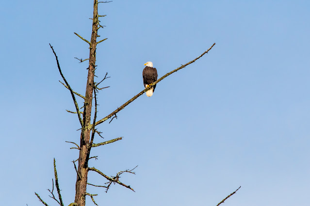
Snag with eagle. No buds on this tree, but there's lichen.

Big-leaf maple. No leaves, no buds, no catkins yet.

~~~~~~~~~~~~~~~
Hay botones nuevos en la hortensia en frente de mi casa. ¿Señal de primavera, tal vez? ¿Una respuesta al clima que este año, hasta ahora, ha pasado por alto el invierno? ¿O un error que se pagará si es que veamos temperaturas de invierno más tarde?

Los alisos rojos ahora estrenan sus candelillas rojizas. Las empezaron a producir en noviembre, y no les espanta el frio, aunque todo se congele.
  1. Rama de aliso rojo, Alnus rubra, ahora en enero, 2025. Las candelillas machas son largas y rojas. Las candelillas hembras son más chicas, redondeadas, verdes cuando están nuevecitas. Tanto las candelillas machas como las hembras salen antes de que aparezcan las hojas, pero las candelillas machas se caerán una vez terminada la temporada de polinización. Las candelillas hembras formarán pequeñas piñas; estas permanecen en el árbol durante todo el invierno, y ahora las semillas están escapando de entre las escamas. Y se ven en la punta de las ramas los primeros brotes rojizos de las hojas.
  2. El árbol estará muerto, pero lleva vida; el águila y los líquenes que cubren las ramas.
  3. Un arce de hoja grande. Este árbol todavía no muestra señas de hojas, ni sus botones, ni las candelillas que aparecerán más tarde.


Powered By Blogger