Showing posts with label google maps. Show all posts

Sunday, December 18, 2022

Mapping my routes

I spend a lot of time mousing down roads on Google maps, zooming in on no-name lakes and tracing the windings of logging roads up and down the mountains. It's not as good as being there, but I often discover trails and sights for future wanderings. Tonight's map showed me something about a place I have stopped at twice before; it looks like I missed something.

I had gone down to the new Upper Campbell Reservoir campground. Just following my whim of the moment: turn here, take the left fork, why not go down to the water, see what's happening today? The campground was quiet, under a few inches of snow, although I was surprised to see several campers, one set up with tents, a full establishment. I'm not the only winter wanderer.

Mists lay low across the hills, turning all the distant colours into dark blues. There was a scent of campfires blended with the smell of evergreen sap. Juncos foraged among the bare stems of shrubs at water's edge.

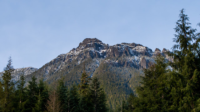
Upper Campbell Lake, from the campground. The sun is attempting to break through the clouds. The blue peak barely visible in the mist is Mount Flannigan, over 1500 metres high.

A closer look at the opposite shore. Bits of the Elk River road are visible.

Downstream, where the lake narrows, there's a trestle bridge. This was close enough for the colours to shine through the mist.

A fork in the road to the campground leads to this end of the bridge. And there, it's gated.

View of the hills beyond the bridge.

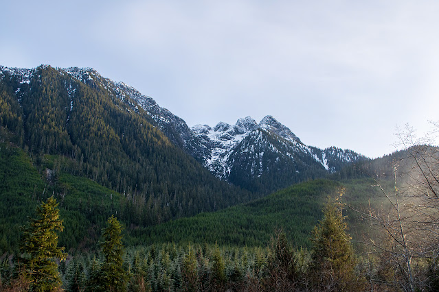
I call these hills the Three Faces. They're low hills, only 600 metres at the highest point, and unnamed on any map I can see.

And here's the thing I saw on the map:

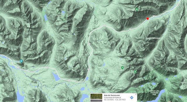
Upper Campbell  Lake, campsite, Hwy 28, and trestle bridge.

There's a figure of a hiker on the bridge! That means that it's accessible on foot. I've been right up to the gate, firmly locked, twice, but never would have dared cross the bridge without some evidence that it was safe. There I have it. When the spring comes, when the serviceberries and wild strawberries at this end of the bridge are in bloom, I'll drive down and cross that bridge. Just because.

~~~~~~~~~~~~~~~~~~~~~~~~~~~~
Paso tiempo viajando por medio del ratóncito al lado de mi computadora, explorando los mapas de Google, siguiendo los caminos de las compañias de madereros y aumentando laguitos sin nombre. No es tan divertido como estar allí en vivo, pero tiene sus beneficios. Muchas veces así descubro senderos que puedo seguir cuando el tiempo lo permite. El mapa que examiné esta noche me mostró algo que no había visto, aunque he visitado el sitio dos veces antes.

Siguiendo el impulso del momento (tomo ese camino lateral, doy vuelta allí, ¿qué tal si bajo al valle? ...) había bajado a ver el nuevo campamento del embalse del lago Upper Campbell. El campamento estaba silencioso, aunque me sorprendió encontrar varios sitios ocupados, uno con todo un establecimiento de vehículos y carpas. Yo no soy la única loca.

La neblina cubría los cerros, cambiando todos los colores distantes por azules sombríos. Había un olor a fogata, mezclada con olor a pino. Juncos buscaban comida entre las ramas sin hojas a la orilla del lago,

Fotos:
  1. El lago desde el campamento. El sol trata, sin mucha suerte, de romper las nubes. La cima de la montaña que apenas se ve entre las nubes es el monte Flannigan, que mide un poco más de 1.500 metros.
  2. La orilla opuesta del lago. Se ven tramos del camino Elk River.
  3. En la dirección opuesta, donde se estrecha el lago, hay un puente de caballete. Esto, tan cerca que hasta se distinguen los colores. Un camino lleva al pie del puente y allí hay una barrera que no permite el paso a los coches.
  4. Vista de los cerros al otro lado del puente. Yo les llamo las Tres Caras. No los encuentro con nombre in ningún mapa, pues son sin importancia, midiendo a lo más alto apenas 600 metros.
  5. Y aquí es lo que vi en el mapa. En el puente de caballete, hay un símbolo de caminante. Eso quiere decir que se permite cruzar a pie. Dos veces, he llegado a ese punto y he regresado a casa, no queriendo arriesgarme si el camino no era seguro. Pero parece que sí lo es. En la primavera, cuando los saskatunes (Amelanchier alnifolia) y las fresas salvajes están en flor, regresaré a cruzar el puente. Porque sí.

Sunday, February 20, 2022

A small strip of forest

 I call it the "little wood". Which makes it sound bigger than it is.

From the 1920s to somewhere in the '50s, the area around Oyster Bay was a logging camp, with eventually over 100 workers' cabins, heavy equipment, and mud, mud, mud. The original forest was wiped out. In the decades since, after the loggers moved out, Scotch broom moved in and completely covered the area.

Since the site was declared a protected park, back in 1996, the broom has been removed (mostly; I saw a few new shoots last week.) The area now consists of the bay with its breakwater, shore birds and ducks and purple martin houses, a long beach on the "outside", gravelly and sandy, then the line of thousands of logs, the sand beyond, and the trail to the rest area. Between the bay and the rest area, there's the dike and the meadow where protected plants thrive. A great mix of habitats in a short walk!

And there's the "little wood"; just a strip of trees and shrubs that somehow survived all that history. A narrow strip, but full of life; here on every visit I find new marvels: mushrooms and lichens, mosses and slime mold, spiders and sowbugs, bees and caterpillars, a mix of native shrubs and trees, deciduous and evergreen.

Google maps image.

A mix of Douglas fir, deciduous trees and shrubs, rotting, moss-covered logs.

Random shot of the ground. Cottonwood leaves, fir needles and cones (two species), moss and Cladonia lichen, fresh evergreen twigs, old wood, grasses and new spring plants.

"Knobby" tree. I have to wait for new leaves to identify it.

Old log with moss and reindeer lichen.

At the edge of the wood, a log laughs in the sunlight.

~~~~~~~~~~~~~~~~~~~~~~~~~~~~
Yo lo llamo el "bosquecito". Lo que lo hace parecer más grande de lo que es en realidad.

Desde la década de los 1920 hasta los '50, el area alrededor de Oyster Bay era un centro de industria maderera, donde en un tiempo existían mas de cien casitas para obreros, gran cantidad de maquinaria pesada, y lodo. Mucho lodo. El bosque original desapareció. Después de que la industria dejó el sitio, fue invadido por la planta invasora retama negra, que lo cubrió totalmente.

En el año de 1996, el sitio se declaró un parque protegido, y voluntarios eliminaron la retama. (No totalmente; vi unos brotes la semana pasada.) El area ahora consiste en la bahía con su rompeolas, sus aves costeras, patos, y las casitas para golondrinas purpúreas; una playa a lo largo del "exterior", con piedritas o arena; luego los miles de troncones, después un tramo con más arena, y el camino que lleva a la zona de descanso. Entre este y la bahía, está el dique y el prado donde crecen plantas protegidas. ¡Una buena mezcla de habitats en un paseo corto!

Y ahí está el bosquecito; apenas unos pocos árboles y arbustos que de alguna manera sobrevivieron toda esa historia. Un tramo angosto, pero lleno de vida; en cada visita descubro nuevas maravillas. Hongos y líquenes, musgos y moho mucilaginoso, arañas y cochinillas, abejas y orugas, una mezcla de arbustos y árboles indígenos, tanto de hoja caduca como perenne.

Fotos:

  1. Mapa de Google.
  2. En el bosque. Abeto de Douglas, árboles y arbustos caducifolios, y troncones bien podridos, cubiertos de musgo.
  3. Una vista al azahar del suelo: hojas de álamo, hojas y conos de abeto (dos especies), musgo y liquen Cladonia, ramitas frescas de abeto, y madera podrida, pasto y los nuevos brotes de la primavera.
  4. Este árbol no lo podré identificar hasta que salgan las hojas.
  5. Un troncón viejo con musgos y liquen de los renos.
  6. Al borde del bosquecito, un troncón sonrie en los rayos del sol.

Wednesday, December 08, 2021

View from the road

 A light dusting of snow. Mountain tops, from the roadside by the site of the ice flowers.

Facing south, with the sun heading down in the west.

And from the same spot, with my back to the sun.

December 3, at 3 PM.

I always want to know what mountains I'm looking at. Difficult, with so many peaks on this crumpled island, so many of them without names on the maps. "Driving" my mouse down the highway on Google maps, I found the spot where I took these photos. It looks different on Google; the trees were still in place back then. But I found the creek that cuts under the highway, and the flat spot I parked on. The highway there follows the bottom of the valley between Tsitika Peak and Jagged Mountain.

Google maps, terrain view.

~~~~~~~~~~~~~~~~~~~~
Un poco de nieve en las montañas, visto desde donde encontré las "flores de hielo".

  1. Mirando hacia el sur.
  2. Y con el sol a mis espaldas.
Esto fue el 3 de diciembre, a las 3 de la tarde. El sol se puso ese dia a las 4:15.

Siempre quiero saber como se llaman las montañas que veo. Algo difícil, con tantas montañas en esta isla toda arrugada, y tantas sin nombre en los mapas. Pero "manejando" por la carretera en Google, encontré el sitio en donde saqué estas fotos. Se ve diferente en Google; cuando ellos sacaron fotos, todavía no habían cortado los árboles. Pero hallé el riachuelo que cruza debajo de la carretera, y el sitio plano donde me pude estacionar. La carretera allí sigue el fondo del valle entre la cima Tsitika y la Montaña Jagged (Escarpada).


Tuesday, February 18, 2020

Log jam pond

Google maps are sometimes amazing.

At one end of the Campbell Lake, there's a side channel that gets lost in a clump of islands and dead ends. There's probably an old creek flowing in here; the river itself leaves the lake from another channel. The highway winds through the hills and valleys along the lake shores, and here cuts off a narrow neck of the lake, leaving only a small drainage culvert under the road. Years ago, a pile of logs were dumped into the upper end, floated down to the culvert, and were stuck. They're still there.

I stop sometimes, to look at the logs. Last week I stopped again. The lake end was frozen, with a light coating of snow on top, and on the logs at the surface.

Cross-hatching

I looked up the lake end on Google maps. The logs can be seen from the overhead view.

The lake ends at the right, at a gravel pit. The lower left channel leads out to the main body of water.

And from the street view, taken in September of 2011, nine years ago, some of the same logs are recognizable.

Even to the weeds growing on the one center front.

They were old, even then.

~~~~~~~~~~~~~

A veces se ven cosas sorprendentes en las mapas de Google.

En un extremo del Lago Campbell, el lago hace una diversión que se pierde entre varias islitas. Parece que aquí entra un riachuelo; el río sale por otro canal. La carretera sigue las costas de los lagos, y aquí hace puente sobre una brecha angosta, dejando solo una apertura pequeña para la salida del agua. Hace años, se tumbaron troncos al agua, flotaron hasta la carretera, y allí se atoraron. Todavía están allí.

De vez en cuando, al pasar, me paro para mirar los troncos. La semana pasada, el agua estaba cubierta de hielo, con unos cuantos centímetros de nieve encima del hielo y de los troncos flotantes.

Busqué el sitio en las mapas Google; se ven los troncos en la vista aérea. Y desde la calle, en su foto tomada en septiembre de 2011, hace nueve años, algunos de esos troncos se pueden reconocer. Son los mismos de hoy; aún algunos de los arbustos que crecen encima de uno que otro tronco se pueden ver.

Quien sabe cuantos años han esperado aquí estos troncos; en 2011 ya eran viejos.

Wednesday, November 13, 2019

View from Highway 28

Someone ripped up a bit of forest and left a mess. And for once, I'm not complaining. They left a view that wasn't there before.

Upper Campbell lake, distant peaks, nearby cottonwoods, November, 2019

The bare trees are maples; they've already lost most of their leaves. Now it's the cottonwoods' turn to warm up the blues and greens.

When Google went by, in 2011, the area closest to the highway had been logged off, but the shoreline and the lake were still masked by trees.

Google map photo, 2011, slightly tinted to render the mountain peaks visible. Taken by Google from the roadside point where I stood to take my photo.

I spent several hours trying to identify those two distant peaks. I think the one on the left may be Kings Peak. Google Earth let me get close, but refused to give me a name.

Google Earth view. Rocks and ice.

Sunday, September 15, 2019

Indian Creek Falls

The World Waterfall Database lists 2465 waterfalls in BC. It misses some, probably quite a few; I've found waterfalls that are not listed, in my limited travels.

Indian Creek waterfall is on their list, though. I didn't know its name until I found it in Google maps then compared with the WWD maps. They have no details on it, except that Indian Creek is a tributary of Udona Creek, which I can't find, except maybe as a darker line on Google maps.

Nameless, or named and listed, it's still worth a stop and a short walk.

Indian Creek falls, the top half of the first drop.

It's a smallish creek, but it drops down a rock face from high above the highway, then runs through a pipe underneath the highway, into a small pool, then drops again into the Gold River, far below.


I have climbed down to the first pool several times, but never thought to follow the pipe under the road. My granddaughter was more adventurous than I.

Ahead, the second pool, and then the drop. Between the nearest trees and the dark woods beyond, is a deep gash in the terrain, with the river at the bottom.

Going out to the top of the second drop.

We walked down the road to the next viewpoint, to look at the second half of the falls. All we got was a hint of white movement; it's visible in the winter, but not in summer, with all the trees leafed out in between.

The lower half of the falls, taken last year. The falls are visible as two white lines on the left.

And in my search of maps and databases, trying to find this waterfall, I discovered others, and other interesting roads I haven't explored yet. So much to see!

Wednesday, March 21, 2018

Beaver Lodge

Last fall, I discovered (but only by poring over dark photos) a beaver lodge near Echo Lake. I passed that way again this week, and the light was better. Besides, I now knew where to look. The beavers are still there.

I think it's bigger than it was last fall. Looks cozy.

I searched on Google maps and found the exact spot. On the street view, taken in September of 2011, the lodge is just visible.

Google street view from Hwy. 28. The lodge seems to be smaller than it is today.

I waited, but saw no sign of the beaver family this time. Other than their home, of course.

Friday, July 01, 2016

Sasquatch!

I was exploring back roads on Google maps, looking for a particular driveway, when I saw it.


Must be a Sasquatch

Zooming in. Oh, definitely, a Sasquatch.

Looks like he has a dog with him.

Looks like a beagle. In a backpack.

And Google refused to zoom in any closer. But I don't think he was there when I drove past the spot.

Powered By Blogger