Showing posts with label Vancouver Island mountains. Show all posts

Tuesday, August 26, 2025

Accurate naming

At the far end of Buttle Lake, I stopped to take a couple of photos. And then, at home, looked up the mountains on the map. As I do, usually.

Had to laugh at this one.

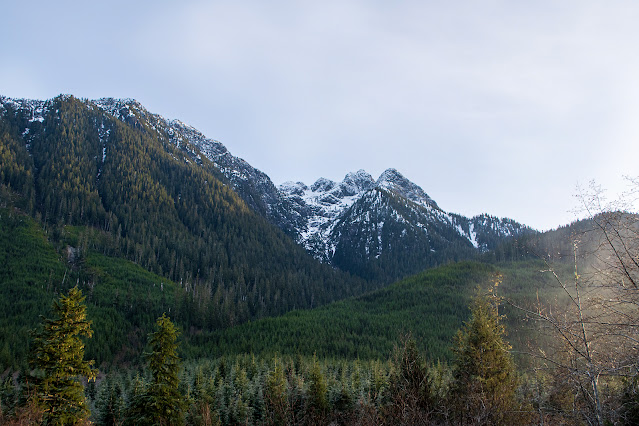
From Thelwood Creek Bridge, looking south.

And looking north, towards the lake.

So: most of Vancouver Island is a mass of mountains. The Golden Hinde, our tallest mountain, at 2195 metres, lies 18 kilometres from my viewpoint.

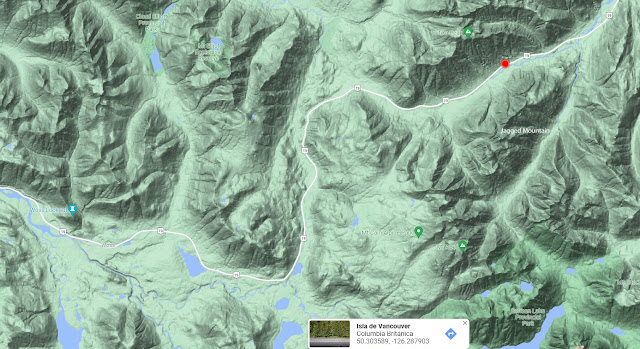
Here's a Google Maps terrain view; you get the idea:

The red star marks the snow-sprinkled mountain in the first photo above. The Golden Hinde is a little to the left at the level of the end of the lake.

And here's the map covering only what I could see from the bridge:

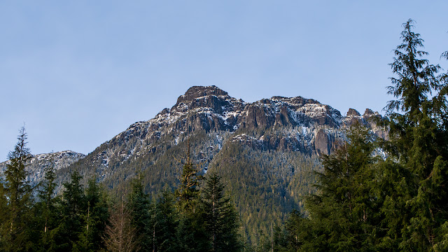
Big Interior Mountain, 1857 m. 11 km, bridge to BIM. View rotated; South to the left.

Big Interior Mountain? A name to distinguish it from the other hundreds of big interior mountains. Good job!

A Skywatch post.

~~~~~~~~~~~~~~~

En el extremo más al sur del Lago Buttle, me detuve para sacar fotos del paisaje. Y luego, en casa, busqué las montañas en el mapa, como acostumbro.

Una montaña me hizo reir.

  1. Vista desde el puente sobre el riachuelo Thelwood, mirando hacia el sur.
  2. Y mirando hacia el lago, al norte.
  3. La mayor parte de la isla de Vancouver se constituye de montañas. El Golden Hinde, nuestra montaña más alta, midiendo 2195 metros de altura, dista 18 kilómetros desde el puente de donde saqué estas fotos. Aquí está un mapa en relieve que lo demuestra. La estrella roja marca la montaña incluida en la primera foto; la que tiene algo de nieve en la cumbre. El Golden Hinde es un poco hacia el oeste desde el puente.
  4. Y un tramo del mapa, incluyendo solamente lo que se podría ver desde el puente. Con esa montaña con nieve, llamada "Montaña Grande Interior", que queda a 11 km. del puente. (El sur aquí es hacia la izquierda.)
¿Montaña Grande Interior? Un buen nombre que la distingue de las múltiples montañas grandes interiores, ¿no? ¡Bien hecho!

Un post para Skywatch.


Saturday, April 19, 2025

North Island spring

It was a beautiful day. I got out early and drove north and north and north, seeing the bright spring colours; all those green glowing lights on the winter's bare branches. The pink catkins of the alders have been eclipsed by the shiny neon-green leaves; the maples have hung out their yellow-flowered racemes; new elderberry and salmonberry leaves brighten the edge of the forest. Snowy mountain peaks play peek-a-boo behind the lower hills, seeming to advance and retreat as the road winds, following the rivers in the valleys.

Down a gravel road, off the main highway, at every turn several robins fly off into the bush to wait until I'm out of sight again.  A squirrel dashes across the road; something chitters at me when I roll down the windows. Where the road ends, in Zeballos, the robins are joined by swallows and crows, maybe a raven.

I turn and head home again, stopping here and there to look at rocks or chase butterflies. Or to balance over a steep bank to look at green, roaring water.

Gravel road. The peaks are in the Haihte range.

Heading west.

Warm day, with ice.

End of the road. Looking back at Zeballos town from the pier.

Really the end of the road. Rock underwater, from the pier.

Double falls, near Fault Creek bridge.

Long view just above the falls, where blue water turns green.

Just a creek, any creek. The road runs alongside.

Next: I stop to look at rocks.

A Skywatch post.
~~~~~~~~~~~~~~~~

Era un dia hermosa. Salí del pueblo en la mañana y me dirigí al norte, más al norte, siempre hacia el norte, mirando los colores vibrantes de la primavera; todas esas lucecitas verdes, resplandescientes sobre las ramas desnudas del invierno. Las candelillas color de rosa de los alisos han dado lugar a las nuevas hojas, verdes neón; de las ramas de los arces cuelgan rácimos de flores amarillas; nuevas hojas de  saúco rojo y salmonberry alegran los bordes del bosque. Cumbres de montañas nevadas juegan a "ahora me ves, ahora no" tras los cerros más bajos, parecen avanzar y retroceder con las curvas del camino, siguiendo los rios a sus pies.

Saliendo de la carretera principal, siguiendo un camino de grava, en cada vuelta varios petirrojos se levantan y van a esconderse entre los arbustos. Una ardilla corre, cruzando mi camino; algo en el bosque está haciendo comentarios cuando bajo la ventana. Donde termina la ruta, en Zeballos, golondrinas y cuervos vuelan, mirando desde arriba a los petirrojos picando la tierra en busca de lombrices.

Finalmente, doy la vuelta y tomo el camino a casa, pero deteniéndome frecuentemente para observar unas rocas o tratar de sacar fotos de mariposas. O para balancearme encima de una roca para mirar aguas verdes, violentas, allá abajo.

  1. Camino de grava. Las montañas pertenecen al grupo Haihte.
  2. Dirigiéndome hacia el oeste.
  3. Un dia caluroso, pero con vistas de hielo.
  4. Donde termina la ruta, en el muelle de Zeballos. Miro hacia atrás, hacia el pueblo.
  5. De veras el final del camino. Una roca debajo del muelle.
  6. Una catarata doble. Cerca del puente Fault Creek.
  7. Extendiéndo la vista más allá del puente, donde el agua azul se torna verde.
  8. Un riachuelo cualquiera. El camino se ve a la izquierda.
Mañana; me detengo para mirar unas rocas.

Un post de Skywatch.

Thursday, February 13, 2025

Snowy/not snowy

 -7°C. That's tonight's temperature. But in the afternoon, all this week, the sun has been shining, and the thermometer soars to above 0° for a few hours. So the snow on trees and shrubs has melted, but on the ground, it's still frozen hard.

I drove west, into the interior of the island, to see what was happening.

Argonaut Road. A logging road, well travelled, wide and well maintained, here heading more or less south. Two logging trucks passed me, one piled high with timber, the second empty, heading back into the hills for another load. In the distance, the sharp peak may be Alexandra Peak, 1982m. Snowy spots on the lower flanks of the mountains are logged-off areas. The snow on the trees is gone.

Echo Lake. It's frozen hard; I walked on it, but those aren't my footsteps. Near the far shore, on the right, a black spot on the ice is a couple of people out for an icy walk.

Echo Lake from under the trees on the shore. None of the vegetation, salal mainly, retains any snow.

But under the salal, the snow remains. This is a small trail between campsites; the tracks seem to be animal prints; I could see no shoe marks.

Going on to Upper Campbell Lake. Here, the water isn't frozen. Echo Lake is tiny, a mere 2 sq. kilometres in area; UCL covers 30 sq. km., and is constantly in motion, feeding the rambunctious Campbell River. The snow on land, however, is mostly ice where people have walked.

For comparison, this is just outside of city limits, a week ago. It was still snowing, and the trees were laden. I was walking back from a bridge where I had been looking for animal tracks, and instead snapped my snowy car.

Some huge icicles, next.

A Skywatch post. 

~~~~~~~~~~~~~
 -7°C. La temperatura en esta noche. Pero en la tarde, toda esta semana, ha salido el sol y el termómetro marca arriba de 0° por unas cuantas horas. Así que la nieve que cayó en árboles y arbustos se ha derretido, aunque en el suelo la nieve persiste e incluso se ha cubierto de una capa fuerte de hielo.

Me dirigí hacia el oeste, hacia el centro de la isla, para ver que pasaba.
  1. Via Argonaut. Un camino de madereros, muy transitado, amplio y mantenido, en este tramo dirigido más o menos hacia el sur. Dos camiones madereros me pasaron, uno apilado de troncos, el segundo vacío, en camino hacia la montaña para recoger otra carga. El pico en la distancia puede ser, tal vez, el Pico de Alexandra, con 1982 metros de altura. En las laderas de los cerros, las manchas blancas, nevadas, son sitios donde ya talaron los árboles. Donde hay árboles, no se ve la nieve.
  2. El lago Echo. Está congelado, y el hielo es grueso y sólido. Yo lo probé, caminando un poco en el hielo, pero las huellas que aquí se ven no son mias. Cerca del la orilla opuesta, en el lado derecho, un punto negro en el hielo es una pareja de personas.
  3. El mismo lago, desde la sombra de los árboles en la orilla. Ninguna de las plantas, por la mayor parte salal, Guaultheria shallon, retiene nada de la nieve.
  4. Pero debajo del salal, la nieve persiste. Este es un senderito que une dos sitios para acampar. Las huellas parecen ser de animales; no vi nada de huellas de zapatos.
  5. Siguiendo hasta el lago Upper Campbell. Aquí no se ha congelado el agua. El lago Echo es muy chico, apenas cubre 2 kilómetros cuadrados. En cambio, el Lago Upper Campbell, se extiende sobre 30 kilómetros cuadrados, y está en movimiento continuo, ya que desde aquí se origina el rio Campbell, un rio bastante activo. En la tierra, sin embargo, la nieve persiste, volviéndose hielo donde la ha pisado la gente.
  6. Para comparar: esto fue hace una semana, un poco afuera de los límites de la ciudad. Todavía nevaba, y los árboles estaban cubiertos de nieve. Yo regresaba, aquí, de un puente donde había estado buscando huellas de animales; no vi nada en claro, y me encontenté sacando la foto de mi cochecito medio cubierto de nieve.
Próximo post: unos carámbanos grandes.


Saturday, May 11, 2024

Moody Blues

View from the dining room at Strathcona Park Lodge. Looking across Upper Campbell Lake to the entrance to the Gold River Valley.

Looking WestSouthWest.

Google Maps view, annotated.

Bumpy terrain, isn't it? On this central and west side of the island, the only flat spaces are the larger bodies of water. Rivers and such aren't really flat; they keep falling over waterfalls.

Elkhorn Mountain, to the left, is the second highest peak on the island at 2194 m. (7198 ft.), only 1 metre shorter than the Golden Hinde, 15 km. to the south. Mount Flannigan, on the right, clocks in at 1556 m. (5105 ft.).

Some of the other peaks bordering this valley entrance, not labelled, are Bear Lair Peak, 1711m., Big Den Mountain, 1774 m., and Trio Mountain, at 1761 m.. Was that a Trio of Bears, or of hikers?

~~~~~~~~~~~~~
Esta es la vista desde el comedor en la hostería de Strathcona Park, mirando hacia el OSO, y la entrada al valle de Gold River, saliendo del lago Upper Campbell.

En seguida, una vista tomada de las Mapas de Google, mostrando la hostería, el valle, y las montañas alrededor.

Terreno quebrado, ¿no? Aquí en el centro y en todo el lado al oeste de la isla, las únicas areas planas son los lagos. Los rios no cuentan; a cada rato caen sobre cataratas.

La montaña Elkhorn, a la izquierda, mide 2194 m. de altura, ganado (y eso solo con 1 metro) por el monte Golden Hinde, unos 15 km. al sur. El monte Flannigan, al lado derecho del valle, mide 1556 m.

Algunos de los otros picos en este rumbo, a los cuales no les puse nombres, son: Guarida de Osos, a 1711 m., Guarida Grande, a 1774 m., y la Montaña del Trío, a 1761 m. Y eso, ¿fue un Trío de Osos, o de montañistas?


Wednesday, December 08, 2021

View from the road

 A light dusting of snow. Mountain tops, from the roadside by the site of the ice flowers.

Facing south, with the sun heading down in the west.

And from the same spot, with my back to the sun.

December 3, at 3 PM.

I always want to know what mountains I'm looking at. Difficult, with so many peaks on this crumpled island, so many of them without names on the maps. "Driving" my mouse down the highway on Google maps, I found the spot where I took these photos. It looks different on Google; the trees were still in place back then. But I found the creek that cuts under the highway, and the flat spot I parked on. The highway there follows the bottom of the valley between Tsitika Peak and Jagged Mountain.

Google maps, terrain view.

~~~~~~~~~~~~~~~~~~~~
Un poco de nieve en las montañas, visto desde donde encontré las "flores de hielo".

  1. Mirando hacia el sur.
  2. Y con el sol a mis espaldas.
Esto fue el 3 de diciembre, a las 3 de la tarde. El sol se puso ese dia a las 4:15.

Siempre quiero saber como se llaman las montañas que veo. Algo difícil, con tantas montañas en esta isla toda arrugada, y tantas sin nombre en los mapas. Pero "manejando" por la carretera en Google, encontré el sitio en donde saqué estas fotos. Se ve diferente en Google; cuando ellos sacaron fotos, todavía no habían cortado los árboles. Pero hallé el riachuelo que cruza debajo de la carretera, y el sitio plano donde me pude estacionar. La carretera allí sigue el fondo del valle entre la cima Tsitika y la Montaña Jagged (Escarpada).


Wednesday, November 13, 2019

View from Highway 28

Someone ripped up a bit of forest and left a mess. And for once, I'm not complaining. They left a view that wasn't there before.

Upper Campbell lake, distant peaks, nearby cottonwoods, November, 2019

The bare trees are maples; they've already lost most of their leaves. Now it's the cottonwoods' turn to warm up the blues and greens.

When Google went by, in 2011, the area closest to the highway had been logged off, but the shoreline and the lake were still masked by trees.

Google map photo, 2011, slightly tinted to render the mountain peaks visible. Taken by Google from the roadside point where I stood to take my photo.

I spent several hours trying to identify those two distant peaks. I think the one on the left may be Kings Peak. Google Earth let me get close, but refused to give me a name.

Google Earth view. Rocks and ice.

Powered By Blogger