Showing posts with label Bella Coola road. Show all posts

Monday, October 12, 2015

Blue hills

I still have a few photos left from the Bella Coola trip: these are from the beginning of the start of the run-up to The Hill (always capitalized like that.

The mountains of the Bella Coola Valley, from near Heckman Pass.

Zooming out to show the gravel road, and a bit of the car motor.

From here, just inside the eastern edge of Tweedsmuir Park, the road goes down, down to a bridge over a creek, then up over a ridge, down again, up again, with each drop more precipitous. And then the road goes stark raving mad, dropping in grades up to 18% (7% is considered a steep hill), twisting and reversing, sometimes down to one rutted lane around blind rock faces, with nothing on your left but a sheer drop down, down, down to the tops of trees and your road below you. And then there is a river, and the road levels out, and you're at the foot of those mountains in the distance of these photos.

Kids drive up and down The Hill for fun. I white-knuckle it, but it's still exhiliarating.

Friday, September 04, 2015

Charlotte Lake and road

In the Chilcotin, the people are hospitable; the land is not. Even at the best, the mildest of times, the end of summer, the soil is hard and littered with dead wood, the trees hard-edged, the mosquitoes vicious. The sun burns painfully, even through fabric. When it retires for the night, the frost sets in. (In winter, the temperature will drop to -40 Celsius.) It's a hardy folk that live there year-round.

I went down to Charlotte Lake, on the edge of Tweedsmuir Park, to spend a day with family in their cabin. The road in starts off the highway as a good gravel road, but gradually narrows, develops ruts, lumps, roots, and rocks, slides down slippery hills. The car fish-tails in the dust. As the crow flies, it's 15 kilometres to the lake; the road meanders, covering 29. Occasional hand-made signs tacked to trees confirm that yes, this is really a road, and you are going the right direction.

It's worth the trip.

Charlotte Lake, in the afternoon. Mornings, it's glassy smooth.

The last straight stretch, at the beginning of the road in.

The trees here grow tall and close together, reaching for sunlight. In spots, most of them are blackened poles, left behind by the fire 5 years ago; green or black, they're all vulnerable to the next spark, the next lightning strike. Along the road, fire prevention crews have cut the forest to make a fire break. Nearer the lake, they are busy thinning the trees, cutting over half of them, leaving several metres between each standing tree.

The residents down at the lake harvest some of these fallen trees for winter fuel, but most are left to rot on the ground; they are the nutrients for the next generation of trees. And hiding places for insects and larger animals, out of the glare of sunlight and the bite of ice.

The trees stand straight, but when they fall, many of them seem to twist, so the grain spirals around the log.
New pine, out in the sunlight at the edge of the road.

Deer, watching me from a safe distance.

Gray jay. Many of these flitted from dry branch to dry branch, never coming very close.

Strawberry blite, aka goosefoot, strawberry spinach.

These grow on disturbed ground around the cabins. All the plants are tiny, in this high and dry valley; the lake is at 3855 feet above sea level.

The red clusters are fruits; edible and juicy. I picked one, and it bled red juice over my hands. The black spots are the seeds. The leaves are also edible. I didn't try them, because every leaf counts in this barren soil.

At the top of Boot Hill on the way out, I stopped to take a photo of the boot tree:

I was tempted to add my shoes to the bottom, but I didn't have spares with me.

Zooming in. The piece of tire reads, "Here Jun 25, 2005 V. (unreadable) lost their boots)

And their flip-flops, their slippers, and their sneakers.

A Skywatch post.

Tuesday, September 01, 2015

Checking in

I'm home. I've got three cameras and the computer full of photos, and some stories to tell. But first things first: sleep. I drove over 12 hours today.

Highway to Bella Coola, at Green River, in Tweedsmuir Park. The road is gravel from here on to the Bella Coola valley.


Wednesday, August 26, 2015

Precarious crossing

I've arrived safely in Bella Coola; it's been an adventurous drive, including a side trip well off the beaten track, following garbled instructions down unmapped roads.

I gave this bit of road at Spences Bridge a miss, even though it's still on my maps. The sign on the highway said only, "Old bridge closed".

Old Spences Bridge, crossing the Fraser River

I've got oodles of photos and stories to tell, now that I have electricity and internet access for a few days; scenery, rocks (not flippable), animals tiny and big, etc. No bears, yet; I'm going to look for some tomorrow.

Sunday, August 23, 2015

Heading north

In a few hours, I'll be on the road, seeing the traffic and smoke of the Lower Mainland fade away behind me. Hope, the Coquihalla, Nicola Valley, Spences Bridge, Cache Creek, Lac LaHache, Bull Canyon, Kleena Kleene, Tatla, Caribou Flats ... the names call to me; I must go. I'll be ending up, eventually, in Bella Coola for a few days, then turn towards home again; the names in reverse.

Crossing the Chilcotin. Photo from 2010.

A flattish spot on the Bella Coola hill. 2010, with smoke.

Part of the time, I'll be camping, with no access to the internet, or, in places, even to a cell-phone signal. I'll log in here when I can, store photos and stories when I can't. And I'll be back the first of September, in plenty of time for Rock Flipping Day.

When I pulled my suitcase out of its storage space, it tore the spider web it was attached to, and the owner came out to complain.

"Hey! That was my house! I built it with my own spinnerets!"

Yes. It's about time I got moving.

Thursday, December 12, 2013

Remembering Josephine's

Sorting photos, I came across this old photo, one of my favourites.

Abandoned house, "Josephine's", tote road, Atnarko River valley.

This was taken in the 1980s, with one of those little Kodak Instamatics, old even then. There iswas an old gravel and mud road following the river from the Bella Coola highway to the trail head going out to Lonesome Lake, the road better walked than driven, even then. From the shade of the forest, you come out to a sunny field, with the silent house in the center, curtains still hanging, doors locked. The trail to the front door is overgrown with tall grasses.

The next house is over an hour's hike away, at Stillwater Lake.

This is one of my best memories; I've dreamed about the house ever since.

Thursday, November 29, 2012

Remembering a Chilcotin summer

I don't think I ever posted these photos of a lake by the side of the road to Bella Coola.

Unnamed lake, near Nimpo Lake, Bella Coola Highway

Yellow scum and brown ducks

The ducks and waterlily leaves

I can't identify the ducks; they're mostly brown, with darker brown heads, dark bills.


Thursday, September 30, 2010

Scenes from the Bella Coola valley

The house is gone. Not demolished, not covered in muck, not under a log jam. Gone. Nowhere to be seen. All that is left is a rectangular pool slowly draining back into the river.

Another house, more fortunate. 2 inches of slippery mud on the living room floor. Along with everything 4 feet of racing water could toss onto it.

A mobile home tilted crazily. A solid house on a rise holding a basement full of river.

A clear road rounds a corner and ends abruptly; there is a 4-foot drop, and then the river. The road picks up again at the next bend.

A highway hidden under a spill of big rocks. Farther along, logs. Better than no road.

A canoe tied up at the gap where a bridge used to be, with a rope across the stream to make it accessible from either side.

A half-dozen white chickens stepping warily out of their coop onto a plank over a new stream.

Just a few impressions of the "morning after" photos from the Bella Coola flood, here, and here.

But the news is good; there were no fatalities, no injuries. Everyone who needed to got out safely. Everyone is accounted for. The horses are back in the pastures (along with a flock of seagulls and the odd duck). The airport is open again, and a detour has been found around the washout on the highway across the Chilcotin. The hill is still closed, and will be for months, but there are flights down from the other side of Tweedsmuir Park; the valley is no longer isolated. There is a ferry on the way, bringing food and other necessities, as well as Bella Coola residents stranded away from home. A barge is bringing fuel and equipment; the bridges will be repaired.

But the locals aren't waiting for help to arrive. They're on the road already with graders, backhoes, trucks and wheelbarrows, cleaning up, repairing, filling in gaps. They're joining their neighbours to clean up the mess inside, with shovels and dustpans and buckets; one resident says, "We had many helpers doing all the dirty work alongside us, so it was almost a party. Not really!"

Not really. The work of a lifetime, for many, has gone in a day. Out here, away from "civilization", many people build their own homes, from scratch, out of local lumber and materials, adding to and modifying them as the family grows and changes. Memories run long in these homes; the kids grew up and went away to the cities to school, to work, to a life elsewhere; they bring their own kids back to spend the summer with Grandma and Grandpa, bedding down in the rooms they slept in as babies.

Yes, most of the damage will be repaired. Ruined homes will be rebuilt, as needed. Some things will never be the same. The valley people will cope.
Years from now people will look back and wonder why that road is the way it is or why some farmer has a nice field while the neighbor's isn't so good. Bella Coola will become relatively normal soon enough, but it will be a slightly new normal. Not everything will get rebuilt and not everything will get rebuilt the way we are used to. I guess that is how the way things have to go. (From Grizzly's blog.)
I zero in on the Bella Coola valley, because my heart is there. Friends, family, the mountains, the green fields and Nusatsum sleeping on his peak; they're in my blood. But the same scenes have been playing all over BC these last few days; floods in the Chilcotin, the road from Tahsis to Gold River washed out, flooding in Kingcome Inlet, Port Hardy, Port Alice, and more. On the other end of Canada, Hurricane Igor hit Newfoundland, causing one fatality, and destroying hundreds of homes. And I'm sure the same courage and resourcefulness is apparent in these places.

One thing I've noticed during the crisis; however far apart we have wandered, when disaster strikes, we come together again. One of the "kids" who live away from the valley started the Bella Coola Flood, 2010 Facebook group. At present, it has 1196 members, about half ex-residents, all sharing news, photos, offers of help. I've been talking with neighbours I haven't seen for 30 years, as if all that time was nothing; we are all Bella Coola valley-ites, and that's what counts.

My family has been talking about arranging a work party to go up and help the family there clean house and collect their belongings, now scattered far downstream. Other young people are doing the same; going up to help mothers and grandparents. A time to cement old friendships; good even comes out of tragedy.

No photos here, again. There are new photos in the flood album, in the Highways' album, and in Michael Wigle's album, more to the point.

Monday, September 27, 2010

First fire, then flood.

I stood at my living room windows and watched the river rise. It had already flooded the meadow across the road and hidden the barbed-wire fence that surrounded it; now it lapped at the far shoulder of the road itself.

It was 1980; I had just bought my house in the Bella Coola valley, a log cabin nestled snugly at the bottom of a rocky mountain half-way up the valley. The property had garden plots on three levels, a good barn, roses, lilacs, and other flowering shrubs, an apple tree (transparents), and below us, below the level of the road even, a lawn with a row of purple plum trees.

I was watching to see if the flood waters would top the road and pour over into my plum "orchard". Otherwise, we were safe, on the first rise of our side hill.

While I stood staring out into the rain and mists, a pickup drove slowly around the bend of the road, and stopped by my corral. A couple of people, unidentifiable in yellow raingear, went to the back and unloaded a skiff, which they manhandled across the flooded fence. They climbed aboard and rowed off in the direction of the river, about a kilometre distant at that point.

Not a good day for a paddle on the river.

They cast about for a bit, then aimed for a spot towards the trees on the down-valley side. Squinting, I could see a shadow on the water there. They pulled up and got out of the skiff. Then nothing.

Later, when the water seemed to have slackened some (maybe it wouldn't flood my plums, after all!), I saw the explorers rowing back. They loaded the skiff into the pickup, turned around and headed down valley.

When the valley had finally dried, the machines came, and built a road to that hummock, the one with the flag at its highest point. There, my new neighbours built their house, high and dry in the middle of a flood plain. Bella Coola old-timers know their river.

That was 1980. The "big" flood that old-timers still talked about happened in 1968; then every single bridge in the long valley was knocked out. The Bella Coola River had carved new channels, undercut the road, and eaten away the land under a fool-hardy newcomer's house, too close to the bank.


Google terrain map of the Bella Coola Valley. About a mile wide at the widest point, 50 or so miles long.

This year, the river has broken all the rules. And suddenly, too; three days ago, residents were remarking at how low the river was for this time of year. And now, it has flooded beyond its 1968 record, beyond the memories of living men. (There was a flood that left the townsite dry in 1936; the previous major flood was in 1896.)

The valley is in the news; here's a report from CBC News. Look at the accompanying photo; the house I stayed in when I visited last month is just on the left of the open area, nearest the river. Fortunately, my hosts hooked up the trailer and moved it up valley when the rains started. My son-in-law says his Dad "doesn't like wet socks." A typical Bella Coola-ite downplaying of difficulties; all his electronic equipment is in his drowned basement, and his wife's prize garden is a rueful memory.

But they're lucky. As before, the bridges have gone. And the water, from 3 rivers and many good creeks pouring down from those tall mountains, has flooded almost the entire valley floor, from the extreme right of my map to the tide flats at the left. Above the valley, the road has been washed out, and will probably not be opened again for several months. The dike separating the airport from the river breached, and the river tore up the runway.

The valley is isolated, as it was for so many years before the road was built. And more; each segment of the valley, split as it is by tumultous rivers, is isolated from the others. Many people got out on time; many did not.   It was all too sudden. A couple of my friends woke up in the morning, dry on the second floor of their house, to find, below, their couch floating around the living room. They got out, in a boat; their horses, as far as I know, are still stranded in the field.

But the valley people are strong and resourceful; they'll survive, though life is going to be difficult this winter. They are working hard, already. Volunteers are out marking damaged spots on the road, shoring up shaky foundations, picking up stranded residents and ferrying them to safety before the next rise in the water.

Because more rain is on its way. It's expected to continue through Monday, and on into Tuesday.

I have no photos, this time. I'm too far away, here in the Fraser Valley. But there is a Facebook group, "Bella Coola Flood, Sept. 2010, with 193 photos. An ex-valleyite started it, others have added more, and those of us who can are labelling the photos for people wanting to know about their families' situations. This photo is of a bridge that went out in 1968; the "temporary" bridge held out this time, but the road access is gone. A hundred people or so are stranded on the far side.

Why was the flood so unexpected, and so extreme this year? I'll explain, next post.

Thursday, September 02, 2010

Busily buzzing bees

On the Bella Coola road, top of The Hill;


Looking down over the upper slopes. That's our road, below, just starting down.


Goldenrod grows well here, at 5000 feet, but is a much shorter plant than at sea level.


The season is short this far north, and the bees don't waste time.


Hurry, hurry! Winter is on its way!

Friday, August 13, 2010

Passing the buck

I blame it on the mosquitoes. And the midges and horseflies.

I should have dawdled more on the road to Bella Coola. I should have taken more time examining the vegetation. I should have taken repeat photos, in case of fuzz. I should have collected a few samples. Now I'm stuck with iffy photos of plants that I can't quite identify.

If only the bugs hadn't been quite so hungry!

I saw this blue/pink/purple bush by the side of the road all through the Chilcotin. It looks like a legume, but what kind? The leaves are palmate, like a lupin's; the flowers have two petals above, fused, two below, I think. The colour varies. The plant itself is about a metre tall, shrubby.  We can't find it in any of our books.


On dry soil, Tatla Lake.


Another, on wetter ground by the river. Tatla Lake.

Near Heckman Pass, in a forest recovering from an old burn, I took a couple of quick shots at some ferny leaves. I didn't even see the old flower heads:


Some kind of lousewort, Pedicularis sp.


The old flower stalks, blown up. It seems that the flowers were pinkish.

At least I recognize these:


Dwarf lupins, pine seedling, and burnt logs.

And this is a salsify, gone to seed:


Also called "oyster plant". Tragopogon dubius. On the Coquihalla Highway.
"... the flowers ... close up at midday or in cloudy weather, a habit that makes them often hard to find and earns them the name 'Jack-go-to-bed-at-noon'."
(From Plants of Coastal British Columbia, Pojar & MacKinnon.)
Smoke has the same effect as clouds; all the flowers were closed:


Yellow flowers are hidden in this closed umbrella shape. Near Alexis Creek.


Tiny lichen, on caked soil.


Top view.

And a horsehair lichen:


Speckled horsehair, Bryoria fuscescens, probably. I like the way it has woven itself into a rope.

Next time, I'm wearing a bee-keeper's outfit.

Thursday, August 12, 2010

Fixer-upper

I've been watching this old hunters' cabin alongside the Bella Coola highway for many years. Nobody has used it since I first saw it.


Local logs, chinked with mud. Built to last.


But the roof leaks.

Wednesday, August 11, 2010

Green, red, blue, and a hidden treasure

The road from Williams Lake to Bella Coola starts and ends on steep hills; up to the Chilcotin Plateau at the east end, then steeply down (up to an 18% grade) from Heckman Pass (1487 m, or 4879 ft.) in Tweedsmuir Park at the western end. I stopped at the top of the hill, to stretch my legs before the tricky descent.


Entering Tweedsmuir Park. The road from here to the bottom of the hill (30 km) is gravel.


Green river. After the blackened forest at the summit, this was a welcome sight.


As the road climbs, clumps of red paintbrush and dwarf lupins appear along creek beds and ditches. I wandered here and there, keeping a hopeful eye out for bears, and swatting the ravenous mosquitoes and midges, seemingly attracted by my bug repellent. Everywhere, there were flowers, with their buzzing pollinators hard at work; the summer is short here, and they don't waste a moment of it.


Red Paintbrush, Castilleja, possibly the Alpine species.


Lupins. At this altitude, they are low plants, usually under 6 inches tall. These, on a boggy creek bank, are taller than most.


A couple of Alpine asters, and the stiff leaves of one of our native berries.

I had been walking for some time before I noticed the orchids. Once I found them, I realized that they were all around, their modest green and white stalks blending into the background. Look closely at the photo of the asters; do you see the orchid?


White bog-orchid, Platanthera dilatata, hidden in plain sight.


 A closer view.


And another.

These are fragrant plants, but I was wearing so much sunscreen and bug repellent that I couldn't smell anything else. Next time, I'll risk being eaten. Somebody has to feed the mosquitoes, after all.

Monday, August 09, 2010

Company on the road

I'm home. I drove down Friday and Saturday, through fire, smoke, lightning, long waits for fire-fighters' go-aheads, road work and rain, with a cramped, damp night's sleep and a warming (heart-warming, too!) cup of coffee with E. of Cicero Sings, and feisty Mingus Saturday morning. I knew I was almost here when I hit a traffic stoppage at 200th Street, with 40 more blocks to go before my off ramp. After an average (I counted and did the math) of one vehicle every 4 minutes on the Bella Coola highway, it made quite a contrast.

I came home, said hello to Laurie, started to unpack, dropped it all and went to bed. I don't think I've been that tired for years. A good tired, though. A challenge taken; can I still drive that road alone, after all these years away? And won through; yes, I can.

It was a good trip, a great visit down in the Valley. I'll have photos and stories as soon as I get them all sorted. For now, here are a few critters I met at various places along the road.


Lacy-winged wasp? On the Coquihalla highway.


Inchworm on our picnic table, Bella Coola.


Red meadowhawk, Tatla Lake.


Another meadowhawk, a bit larger. Tatla Lake.


Brown ducks. One of the many shallow lakes or ponds between Tatla Lake and Alexis Creek.


The lake. The ducks are those brown spots just in front of the floating vegetation.

The insects seem to be very calm or even tame, along here. Most of the difficulty of photographing them was finding them on a plant that the wind wasn't whipping about. The inchworm wandered around our table, not at all worried about our glasses and map books. When I put down the camera, he climbed on it and went exploring. Only the dragonflies and grasshoppers flew away when my shadow fell on them.

The ducks were definitely not comfortable with humans, maybe because many of the local humans are hunters for the pot. They were close to the shore until I stopped the car. By the time I had stepped out, they were speeding out to the centre of the lake.

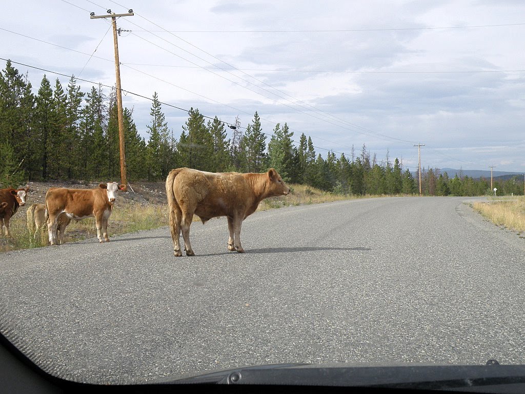
Range cattle, on the other hand ...


... like to stand in the road to get a good look at you before you inch past. I always slow down, because there's no telling when they'll decide to claim ownership of the pavement.

Every so often, there are cattleguards; grids of a dozen or so metal bars across the road, with gaps too wide for the small feet of a cow. With the fences, they are supposed to keep the herds in their home territory.

The cattle may be too smart for them. My son-in-law saw a herd come to a guard. One by one, they stopped at the edge, examined the grid for a minute, then hopped across. I never saw a cow hop before; very funny, that big bulk making a dainty "hop!" up, and over, coming down as neat as a ballerina. They all made it, even the calves. He has video; if he loads it to YouTube, I'll post a link.

My daughter and I saw two bear cubs in a pair of apple trees; they got away before I had the camera ready. I saw a stag with a large rack, far away in a field, many cute chipmunks crossing the road and something large and brown, but too small for a bear, slinking away into the bushes. I found moose droppings ...


... but no moose. (Meese?)

And I'd never seen a herd of range horses on the road before. There were a dozen standing in the centre, in a circle, heads in, butts out, like footballers in a huddle. Three stood on the side, waiting.


One is branded N/C, another AI.

On the way home, I found a dying moth in a campsite washroom:


Resting on my towel. Near 111 Mile House.


I went looking for bears, and didn't find any. That's another story, for another day.

I'm off to bed. Tomorrow, if it isn't raining, we're back to our usual haunts.
Powered By Blogger