Showing posts with label trail. Show all posts

Thursday, September 28, 2023

Trail to nowhere

 As the crow flies, it's about 1 kilometer there and back, from our parking spot on the side of the road to the ravine where the trail gets steep, more challenging than I'm looking for most days. The trail was not mapped out by crows; it follows, more or less, a lazy, meandering creek at the bottom of a ravine, branching out here and there as someone — a deer, maybe, or a bear — went looking for huckleberries or fresh blackberry leaves or took a shortcut to the creek to get a drink. We humans follow their tracks, ending up at a dead end, or looping back into the main trail. Where we wander, our footprints widen the path.

The area is surrounded by "civilization"; highways, an airport, a housing development. But under the trees, all this disappears; we find bear tracks, torn moss where a bear dug for ants or grubs. Birds chatter in the branches, an eagle soars by overhead.

These are mixed woods, mostly deciduous, once heavily logged off. And in this small area, we find a variety of habitats. These are photos taken along the trail.
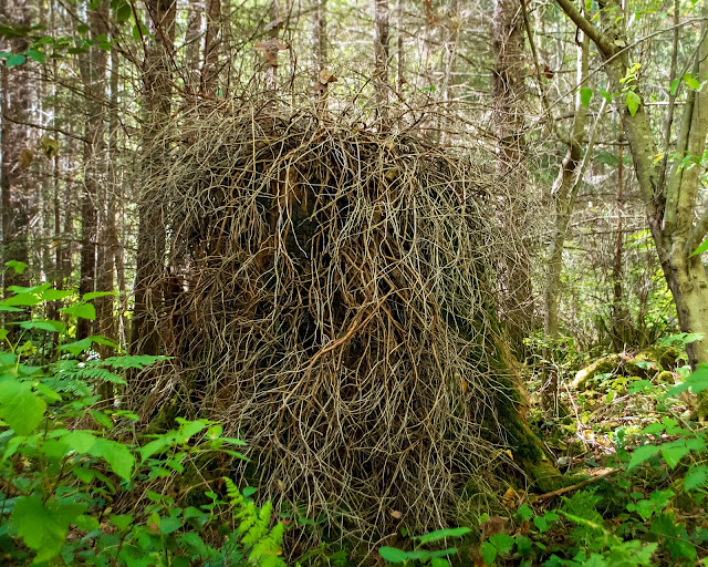
Stump having a bad hair day.

This was one of the ancient giants, a wide evergreen base, badly burnt, somewhat mossy. It had served as a nurse to this branchy shrub, which now has died, leaving a tangle of dried twigs.

The brown land

Down one side trail, we walk through an area with almost no underbrush, just the bare soil, covered thinly by dead evergreen needles (not green any more). The lower branches are mostly dead, but the green roof above provides shade. This was where we found bear scrapings and tracks. 100 metres or so along, we're back in the usual shrubby green wood.

The creek at the bottom of its cut.

The ravine isn't deep, but its sides are steep, and the soil loose. Dusty at this time of year, probably oozy after it rains. The rope in the photo provides a handhold on the way down. At the bottom, the creek slides by without a ripple; when someone came near, waterstriders scattered away across the surface of the water.

The trees here are mostly alder, big-leaf maple, and Douglas-fir. In the understory, in this photo I see salmonberry, huckleberry, and elderberry shrubs, mostly berry-free at this time of year. The ferns are the evergreen sword ferns. Looking closely, I would expect to find Oregon grape and our native trailing blackberry vines. And moss, of course.

At the top of the hill, the trail goes steeply down into the next ravine to cross another branch of this same creek; just beyond this, the main highway marks the outer edge of this tranquil patch.

Salal, huckleberries, willow, alder, Douglas-fir, bracken ferns, serviceberry branches. And grass. Another "accidental" trail.

This photo is from a similar area, about 5 kilometers distant. The same mix of vegetation shows up.
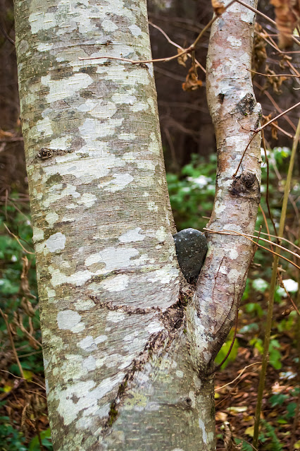
And we came across several stoned alders:

Stoned alder

They had stones caught and held in the angle of their branches. This one was about a metre above the ground, well wedged in; the tree has grown around it. Looking around the area, I found no stones similar. How did the trees collect them?
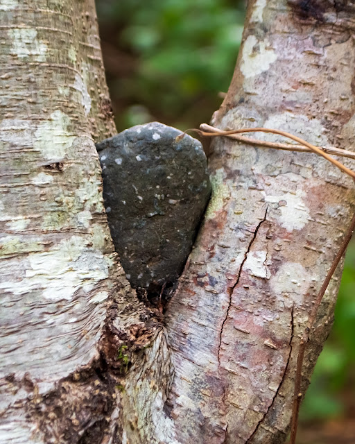
Detail of the stone. The trunk has grown to cement it in place. I couldn't move it.

~~~~~~~~~~
A vuelo de pájaro es como un kilómetro, de ida y vuelta, desde donde estacionamos el coche al lado de la calle hasta el barranquito donde el sendero se vuelve un poco más difícil de lo que tengo ganas de atreverme más que uno u otra vez. El sendero no lo planearon los pájaros; sigue, más o menos, el riachuelo que vaga sin prisas al fondo de su arroyo; el sendero se divide donde alguien — un venado, probablemente, o un oso — fue a buscar frutas de huckleberry, o hojas frescas de mora, o donde se alejó del camino para ir a beber del riachuelo. Nosotros los humanos seguimos sus huellas, ampliando con nuestras pisadas el nuevo caminito.

El sitio está rodeada de lugares "civilizados", carreteras, un aeropuerto, un complejo habitacional. Pero aquí bajo los árboles no lo sentimos. Hallamos huellas de osos y sitios donde desplazaron el musgo en búsqueda de hormigas o gusanos. Entre la ramas cantan los pájaros; muy por encima pasa un águila.

Este es un bosque mixto, talado desde hace años. Y en este sitio pequeño, hallamos varios tipos de habitat. Estas son algunas fotos que saqué al caminar.
  1. Tronco "enfermera" con el "pelo" desordenado. Este es uno de los árboles grandes originales al sitio, ya bien quemado, cubierto de musgo. Sirvió de base a un arbusto que ahora ha muerto, dejando solamente las ramas secas entrelazadas.
  2. "Las tierras muertas". Entrando en un camino al lado, entramos a este bosquecito de árboles bien separados, casi sin arbustos del sotobosque. El suelo lleva nada más una capa ligera de hojas de los abetos, ya secas. Casi todas las ramas inferiores de los abetos están muertas, pero allá arriba la copa de los árboles se mantiene verde. Es aquí donde encontramos las huellas de oso. Unos 100 metros más adelante, volvemos al bosque "normal" con un sotobosque espeso y verde.
  3. El barranquito, con el riachuelo allá al fondo. El barranco no es hondo, pero el pendiente es abrupto y la tierra floja. El lazo que se ve en la foto sirve de sostén al bajar. En el fondo, el agua pasa tranquila, casi sin ondas. Cuando pasa alguien, los insectos llamados patinadores de agua se dispersan rapidamente. Los árboles que se ven aquí son alisos, arce de hoja grande, y abeto de Douglas. En el sotobosque se encuentran los arbustos de salmonberry (Rubus spectabilis), saúco rojo (Sambucus racemosa), y arándano rojo (Vaccinium parvifolium), ya en esta temporada del año sin frutas. Los helechos son los helechos de espada, Polystichum munitum. Si buscara con cuidado, esperaría ver las enredaderas de nuestra mora nativa y las hojas brillosas de uva de Oregon. Al subir el pendiente al otro lado, se encuentra otro barranquito, y pasando este, llegamos a la carretera principal que marca fin a este bosque.
  4. Esta foto es de un sitio parecido, a unos 5 kilómetros de distancia. Se ven aquí más arándanos, alisos, abetos de Douglas, además de salal (Gaultheria shallon), saskatún, sauce. Aquí los helechos son el helecho águila, Pteridium aquilinum.
  5. y 6. Esto también vimos: algunos de los alisos han capturado piedras y han crecido de manera que las detienen firmemente. Esta está a más de un metro arriba del suelo. Como es que el árbol la logró atrapar no me lo imagino. La traté de separar del tronco; no pude.

Wednesday, July 01, 2020

Where the trail goes

And now the foxgloves are in bloom. In open spaces in the bush, along the highways, on lake shores; wherever the sunshine can reach.

I drove west, looking for a spot where I could get close to a patch. Once I was beyond the bustle of the city and the outlying businesses, gravel pits and the like, I looked for a stretch of highway with enough of a shoulder to get out of the way of trucks, far enough away from sharp curves for visibility (not so easy on the way west), away from deep forests, and with a shallow enough ditch for me to cross. And no blackberries in the ditch. Not an easy search.

Near Echo Lake, I found a suitable spot. And across the highway, a narrow path led off behind the trees.

The trail leads down the hill.

I often wonder about the little trails I find. Who makes them? Who goes from here, where there is nothing, to there, where there is just more bush?

The trail here was narrow, at times barely the width of a shoe. Not a bear trail; too narrow. Not a deer trail; it was too consistent, and there was no scat. Rabbits, maybe; where there was grass, it bent over the trail, making a tunnel. It had been used recently; some of the grass lay flat, and I saw a broken yarrow stalk, the flowers still fresh.

Humans, maybe a fisherman? But the trail meandered too much; uphill, then down, to the left, to the right. It finally led over the side of the hill, a steep climb, as I realized on the way back.

Tiny wild raspberries beside the trail. One has only one seed.

At the bottom of the hill, a gravel road skirted the lake.

Elk River Road.

I looked for it on Google maps later. The road leaves the highway on the far side of Echo Lake, passes a couple of campsites, then wanders east and south, almost randomly, for 17 km, until it ends up back on the outskirts of town. A logging road; there is nothing there but old logged-off forest, growing back. Side roads lead to clear patches, more recently logged.

On the far side of the road, the trail drops down through thick forest, and ends at the side of the lake. Mirror Lake, I learned from Google maps.

(The satellite view on Google maps is so good that I could even see the bush that the trail bends around before it drops to Elk River Road.)

And there were foxgloves.

Foxglove patch on the hillside above me.

And foxgloves beside Mirror Lake.

Foxgloves come in white, pink, and deep magenta.

On the way back to the highway, I picked a couple of handfuls of huckleberries. And then I came home.

~~~~~~~~~~~~~~~~~~~~~~~

Ahora las dedaleras (Digitalis purpurea) están en plena flor. Crecen donde hay sol, al lado de la carretera, en espacios abiertos en el bosque, al lado de laguitos.

Salí a buscarlas. Quería un sitio donde podría llegar cerca sin luchar contra moras o trepar en tierras movedizas. Tomé la carretera hacia el oeste, dejando atrás la ciudad y los sitios alrededor donde excavan grava, donde los camiones van y vienen. En la carretera, buscaba un sitio para estacionarme que tuviera suficiente espacio al lado del camino para no bloquear el paso, que no estuviera demasiado cerca de curvas donde no se puede ver lo que hay a la vuelta (algo difícil en esta carretera), donde el bosque no estuviera muy denso, donde la zanja no fuera muy honda, y donde no estuviera cubierta de moras. No era fácil de encontrar.

Cerca del lago Echo, encontré un sitio adecuado. Y al otro lado de la carretera, un caminito se dirigía atrás de los árboles.

Me intrigan estos caminitos. ¿Quién los hace? ¿Quién va desde un sitio sin nada hacia otro sitio que no es nada más que más bosque?

El caminito era angosto, a veces no más que el tamaño de mi pie. No era camino de osos: demasiado pequeño. Ni venados: ni había bolitas de venado, ni huellas, y el camino era demasiado consistente. Los venados brincan.

Tal vez lo hicieron unos conejitos. Donde había pasto, se doblaba para hacer un túnel del tamaño apropriado.

Y se había usado recientemente; pasé una planta de milenrama rota, con las flores todavía frescas.

¿Alguna persona? ¿Un pescador? Pero el caminito vagaba demasiado; iba para arriba, luego para abajo, hacia la izquierda, hacia la derecha ... Por fin bajó el cerro y llegó a otro camino, un camino de grava.

Lo busqué luego en las mapas Google; es un camino de madereros que da vueltas por el rumbo por unos 17 kilómetros hasta regresar al pueblo. Y aquí cruza por el lago Mirror (Lago Espejo).

El caminito baja hasta el borde del lago, y allí termina.

Y había dedaleras, en el cerro, y al borde del lago.

Las frutillas en la segunda foto son frambuesas silvestres. Muy pequeñas, no muy comunes.


Saturday, May 09, 2020

Hidey-hole

It was a day of contrasts. The sun was blazing out of a blue sky. But in the forest, the shade was deep and the tree trunks made tall, dark stripes. Far above, the new leaves, maple and alder, glowed in the light, green and yellow, almost neon colours.

View from the road.

I followed a road that leads to campsites and trails above the highway. They're all off-limits now, because of the virus: Parks Canada says they can't carry out the necessary sanitation on campsites and other park amenities, so they've barricaded entrances to the park areas. But outside the park, the forest is open. I drove slowly, enthralled by the unfolding scenery.

At one point, a narrow footpath led off into the woods. There was no sign, no notice: Keep Out!. I parked and went to investigate. The trail climbed a mound of road-building leftovers, then dropped into the forest. And came to a dead end.

Fallen trees over the trail.

The trail led under the logs: I had to crawl to continue, but then on the far side the path was clear, a well-travelled footpath a foot wide. Not a bear trail. The soil was too well packed, and there were no bear markings or scat. Not a deer trail. Too solid for a raccoon trail. Must be human. But why? It led straight ahead through the forest, towards a glowing light beyond.

Open woods.

Where the trees ended, the trail dropped straight down a steep, muddy, slippery slope. I had to hold onto tree branches as I went, to keep from falling.

And at the bottom, a creek. A creek with deep, dark pools reflecting the golden light overhead.

View from the bank

Reflected tree, detail.

And in the ferns beside the creek, there were a dozen or so empty beer cans. So: a human trail, probably someone's favourite hiding place.

The spot was so peaceful, the reflections so intriguing, the gently flowing water so mesmerizing that I stayed a while. But eventually, I climbed that slope (not on the muddy trail: on my hands and knees up a mossy bank) and followed the trail back through the woods, under the logs, and back to the car.

I won't go back: the creek is someone's secret haven.

~~~~~~~~~~~~~~~

Era un día de contrastes. El sol brillaba fuertemente en un cielo azul. Pero en el bosque había sombras, y los troncos se veían oscuros contra la luz. Arriba, las hojas nuevas (maple y aliso) eran como llamitas verdes y amarillas, de colores ¡tan fuertes, tan fosforecentes!

Seguí un camino que nos lleva a sitios para acampar, y a un red de caminos por el bosque, todos cerrados ahora por lo del virus. Parks Canada no puede hacer la limpieza necesaria en las instalaciones (tomas de agua, mesas, sanitarios), así que han puesto anuncios en cada entrada a los parques prohibiendo el paso. Pero el bosque fuera del parque está libre.

Manejaba despacito, mirando la escena, las luces y los troncos cubiertos de musgo. Vi un caminito, apenas el ancho de un par de zapatos, que entraba al bosque. No había ningún letrero: este camino está abierto. Me estacioné y entré.

Y el camino terminó de repente. Se habían caído tres troncos, uno encima del otro, cortando el paso. Seguí a gatas, y encontré el camino del otro lado, yendo directamente por el bosque hacia la luz tras los árboles.

No era camino de osos; demasiado marcado, y sin troncos rotos, o excremento de oso. Ni venado; los venados apenas marcan el suelo. Los conejos y mapaches hacen caminos angostitos que apenas se ven. Pero ¿que haría una persona aquí?

Llegué al fin del bosque. El camino bajaba por un banco lodoso, muy inclinado, muy resbaloso; tuve que detenerme de ramas de un árbol para no caer.

Y abajo, un riachuelo, tranquilo, hondo, muy silencioso, reflejando los árboles y la luz de arriba. Y en un nido de helechos, una docena de latas de cerveza. El escondite de algún humano, buscando paz.

Me quedé un rato; el lugar era tan tranquilo, los reflejos tan bellos, el movimiento lento del agua algo hipnótico. Pero por fin, me trepé otra vez hacia el bosque (a gatas entre el musgo para no llenarme de lodo), crucé el bosque, gateé bajo los troncos caídos, y regresé al coche.

No volveré; es el lugar secreto de otra persona.

Sunday, January 27, 2019

Canyonview Trail

It's mushroom season. On a short (very short: I've been rather sick over the Christmas season, and still haven't got my strength back); ... a short walk along the Canyonview Trail beside the Campbell River, I took well over 100 photos, mostly of mushrooms, mostly tiny. I'm working now on processing and possibly identifying them.

Meanwhile, here's the trail itself:

A well-travelled trail. It's a few minutes from downtown, easy walking, with good parking at several points along the trail. Cedars, Douglas firs, hemlock, Bigleaf maples, red alder, ferns, more ferns, moss. Moss everywhere. More moss. And mushrooms.

Light and dark. The sunlight shines on the far side of the river; here, we're in permanent shadow.

When I was a kid, I would have called this a good climbing tree. Many, nicely separated branches, soft padding on each branch in case you slipped. Getting too old and stiff now, but I can still dream.

Where the sun shines through, each mossy trunk and branch is outlined with yellow-green.

At river's edge, the remains of an old stump hosts mosses and lichens. And - do you see it? - a baby huckleberry shrub.

Not a drowning buffalo/unicorn.

Tuesday, January 15, 2019

Your pick of trails

Hoomak Lake is half-way up the north end of Vancouver Island. There's a rest area beside the highway there, with picnic tables and maps and clean rest rooms. It's a good place to take a break, on a long, mostly empty highway. From the parking lot, the lake is just visible through the trees. I had found a sort of trail, steep and sllppery, down from there to the lake side on previous stops.

This time, I noticed a trailhead sign half hidden behind the restrooms. With stairs down to the lake. Nice! I went on down.

View of Hoomak Lake from the steps.

And from the landing.

From there a trail, wide and well travelled, leads off towards the upper end of the lake. I can't resist a good trail.

Looking back from above the trail.

In the year 2000 (I discovered from a sign up top later on) the trail had been improved with interpretive signs. They're old now, some badly spotted and smudged, but still legible, although some now point to trees or stumps ("just in front of you," they say) that are no longer here.

"Old Railroad Grade"

Legend: Old Railroad Grade.
You are now standing on an old railroad grade that was used for log hauling for about 22 years. Originally constructed here in 1955, this branch line ran from Woss Camp to Croman Reload, about 5 km west of here.
Croman Reload was one of several locations in the Nimpkish Valley where loads of logs were transferred from truck to railcar. Croman Reload became inactive in 1980 and this connecting rail line was taken out.
At one time, steam locomotives chugged along the rails, pulling their log loads right where you are now standing. More recently, diesel-electric locomotives hauled logs here. Canadian Forest  Products. Ltd. still uses these today in the Nimpkish Valley.

After a short walk, made longer by stopping to read the signs (more on this later), I came upon a new sign, still white and clean.

Long trail, short trail, and just plain trail. Take your pick.

I took the short trail. There was no way of knowing how long that long trail would be.

The short trail turned and went back up the bank, turned again to return to the parking lot. After a bit, I found another sign:

Long trail, short trail again. I took the short one.

Up top, I found a map of these trails.

So the long trail is fairly short, too. Next time, I'll take that one.

One more sign, for those who see water and think "Fish!":

Good Fishing

Legend: If you look across Hoomak Lake from here, the distance is about 700 m to the other shore. Hoomak's length is about 1800 m. Hoomak Lake offers good fishing and canoeing opportunities. It was stocked with10,000 cutthroat trout between 1984 and 1991 to supplement its natural trout population.
Look for a variety of birds on the lake, including ducks and Trumpeter Swans (in the late fall and winter months). Along the shoreline, watch for birds such as sparrows, juncos, wrens and warblers, plus woodpeckers in the older trees.

What I learned from the rest of the signs, next.

Sunday, September 04, 2011

Of boom boats and donkey engines

On a hot summer's day in Powell River, there is no better place to be than in the forest and near the shore. For example, on the Willingdon Beach trail.

The trail used to be part of a railway that hauled logs to the mill at the north end of town. This track was in operation only from 1910 to 1918; afterwards, the rails were removed and the trail was used by mill workers living to the south, in Westview. Now it has become a popular easy walk for local residents, with shade, access to beaches along the way, interpretive sign, native artifacts among the trees, and old logging equipment rusting quietly in the shade.

I had to stop and examine each of these machines. They brought back vivid memories. I grew up, so long ago, on the west coast of Vancouver Island, seeing the loggers working up and down the hillsides along the shore; I remember the chugging of the donkey engine, the clatter as a log danced down the hill, the shouts of the fallers ("Timberrrrrrr!"), the rumble of loads of logs tumbling into the water to be hauled away in big booms. So different, these days, with the operations on mountainsides far away, the hills shaved down to the dirt, the logs (so much smaller these days - mere toothpicks!) picked up in mouthfuls by big-toothed monsters.

Boom boat.

These little round iron tugs push and pull around logs many times their size, maneuvering them into position in the booms, wallowing around half swamped, it seems, with the water washing over the decks . Laurie wondered how they floated; they look too heavy, but they enclose a lot of air in the deep hull. I found a video showing one at work. Fun to watch!

Minimalist pilot house.

Controls of a large caterpillar.

I don't know what this contraption did. It looks fairly new.

A winch.

On our west coast mountains, in the absence of machines that could carry logs, they were attached to steel cables, dragged into an upright position, and winched down the mountainside. The winches also dragged machinery into position.

The donkey engine.

Every operation had a donkey engine, in those days. It was a steam boiler on a sled, powering the winch which it used to drag itself up the mountainside. There, its cables were attached to the top of a spar tree, the tallest, sturdiest tree on the site. The cables ran down the hill to the dumping wharf. Harvested logs dangled from the high cable as they made their way down to the water.

Logging was a labour-intensive industry then; the slopes swarmed with men, cutting, trimming, and fastening logs, clearing brush, tending the few machines. Wood, even though we were surrounded by it, was still costly, in terms of man-hours. But our houses were smaller, lumber was recycled; none was wasted.

Two of the signs near the donkey engine were interesting:


That donkey engine weighed 16,300 pounds!

Thanks, Margy, for the suggestion. I loved this trail!


Saturday, February 23, 2008

Terry Street Stairs: Overhead, underfoot and on the rocks

The cliff face from White Rock to Kwomais Point is steep, high, treacherous and prone to mudslides. That hasn't deterred the residents of the upper slope from making tracks to the beach; walking the railroad tracks at the bottom, we see trail outlets at every little gully or creek mouth. Some are private, some public, some well-built, railed paths and staircases, some just a few boards or logs jammed in the muddiest spots, some foot-paths made by running and sliding teenagers. On the way down, trails or staircases from the individual houses above angle across the slopes to join the main routes.

None of these trails are mapped. None are visible on Google maps; the trees above hide them.

We have been driving down each short street and alley off Marine Drive, scanning the gaps between houses, looking for a way down. Our latest find, last Thursday, is at the dead end of Terry Street (one block long).

199 solid steps, railed, and a long, sometimes steep trail.

This is a lousy photo; my camera protests at the difference in light and dark; the houses above in full sun, aimed at from the dark of the ravine. But it gives an idea of the terrain. This was from about 1/2 of the way down. The bare patch on the right is a mudslide scar. Laurie has scrambled across the blackberry canes to the creek; off the trail.

trail
Not very pretty. Looking back up, anyhow. Tangled, scrubby bush, overrun with blackberries, dry and brown at this time of year.

But look down!

hill
Quite a bit more climbing to do, and then the blue ocean.

On these slopes, the trees, alder, pine, birch, etc., adopt fantastic shapes, lop-sided and broken. Several had recently fallen across the trail and been chain-sawed out of the way. In a couple of spots, the trail was sprinkled with sawdust from woodpecker carpentry too far above to locate.

tree
All to one side. Some repair work done with a chainsaw.

tree
Nothing left but the bare trunk.

trees
Overhead, a delicate tracery of branches and last summer's leaves.

sprouting bush
At ground level, spring growth is on its way, straight and true.

This showed up on my screen, but was barely noticeable to the unaided eye:

shadow
On the mudslide scar, the shadow of an evergreen behind me.

One of the fallen trees, sawed off where it crossed the trail, is turning purple:

crust fungus
Some sort of crust fungus.

Here's a close-up, a bit fuzzy. (In real life, as well as the photography.) Look at that furry back!

crust fungus
On another downed trunk:

lichen
Tiny green lichen.

yellow jelly fungus
And a yellow jelly.

yellow jelly fungus
Looks good enough to eat.

beach
Down at the bottom, several flocks of diving ducks kept well beyond camera range. Seagulls flew overhead and away. But this guy stood his ground. When we came too close, he picked up the treasure he was guarding, and retreated to the water's edge. We kept coming. He hopped over to this rock, and stood, holding his trophy. "Mine, mine, all mine! You're not getting any!"

It looks to me like part of a large crab. Probably stinky. We didn't want any.
Powered By Blogger