Showing posts with label Highway 19. Show all posts

Saturday, December 11, 2021

Homeward bound

There's something about a lonely highway. It grabs me, draws me on and on and on ...

This is a photo taken through my windshield 5 minutes after sundown, lit only by the fog and my headlights.

Hwy 19, heading south from Lake Hoomak. 4:21 PM

~~~~~~~~~~~~~~~~~~~~~~~~~~~~~~~

Algo tiene una carretera solitaria. Me toma presa, me obliga a seguirla. Y seguir ...

Esta es una foto sacada desde mi asiento atrás del volante, saliendo del lago Hoomak camino a casa, unos 5 minutos después de la puesta del sol, y con la única luz la de la neblina y los faros del coche.

Wednesday, January 08, 2020

Somewhere there is sunshine

I had the afternoon free and the camera packed. But the day was a dark grey, with patches of rain. Too dark for photos, too unpredictable for walking. And the tide would be high again until after dark. (Sunset was at 4:38.) Time to get out of town; maybe I could find the sun.

I decided to go north. That way, I might find snow, too. The camera and I would like the light; sunshine on snow!

Fog, fog, rain, fog. And more fog. The only colours visible in the watery light were grey, dingy browns, and the greyed dark greens of the evergreens. After the Sayward turnoff, about 50 km from home, where the highway climbs into the hills (and there are warnings to carry chains) snow started to show up on the side of the highway. And up ahead there were tiny patches of slightly blue sky. I drove on, hoping.

I found sunshine!

See? Sunshine on the trees and the valley beyond! No road goes there, though.

The sun came and went, playing peekaboo behind the mountains, then merging back into the fog. Tall trees bordering the highway hid the mountain peaks. I found an abandoned logging road and went up to get a better view.

My logging road. A few metres farther up, and the view was gone. The light patch on the hillside is a clearcut logged area.

Around the next bend. No sunshine visible from here. A bit of snow, behind the trees on the left.

The highway dipped down into the Woss Valley and the roadside snow disappeared. Fog settled in again. Farther north, it started to rain. I turned around and came home. There was snow on Mount Huksan, behind Sayward, visible sometimes when the clouds lifted for a moment. Dim fog merged gradually into dimmer twilight, even before sunset.

I was glad to see the lights of home twinkling over the water under a foggy full moon.

Wednesday, February 27, 2019

Elk signs, yellow, brown, muddy

Signs along the highways, going north or west from here, say "Elk", with a distance, such as 55 km. Or they show an outline of an elk, with the distance.

Elk sign, Highway 19.

I keep my eyes open, watching the road and the bushes along both sides. I never see an elk. Not in the daytime, not at night. Many deer, at any hour, but no elk. Not a hair.

On a hillside above the Salmon River, I found a different kind of elk sign.

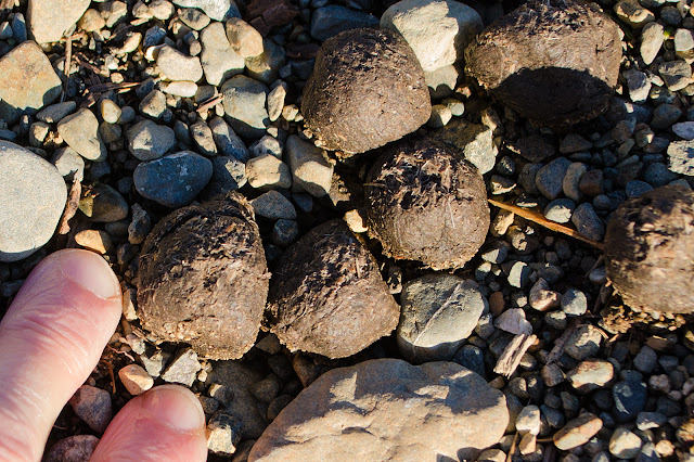
Elk scat. About the size of brown marbles. Fairly fresh, still moist.

A closer look. They're slightly squarish, a hair longer than they are wide. That bit of glitter at the left is ice.

Farther along, I found more:

This scat is older, drying and splitting. My fingernail is 1.5 cm. at the wide point, so the largest of these is about 3 cm. long. The scat contains quite a bit of fiber; their diet at this time of year includes dried twigs, branches, whatever has survived the winter weather.

Elk droppings are bigger and longer than deer droppings. Moose are even larger yet. If the droppings are dry and cracked, it is because they are old and not left there recently. If they still glitter & shine from moisture and each one spreads like grainy peanut butter or room temperature chocolate chips when you slide your boot across them, it could have been minutes, or an hour or two, depending on the weather. If they are still steaming in the cold morning air, they’re close by!  (All About Moose)

No steam seen. The elk had left the immediate area. I wandered about, looking behind piles of logging slash, to be sure. No elk. But I did find this:

There's a baby!

Near a stream, where the water crossed a logging truck access, the gravel was soft, so that elk feet sunk deeply. Here, and nowhere else, I found the little tracks of a calf, still too small to make an impression on more solid ground. The deep end is the rear of the track.

With my muddy shoe for comparison. The bottom of the track is about 4 inches long. The scruffy area at top is caused by her dewclaws, which will leave no impression on a more solid surface. She and her calf were walking peacefully; when she runs, her toes spread apart in a V.

Another print near the muddy area. The dewclaw marks are clear.

So: still not an elk, but closer. Maybe next time.

Tuesday, February 26, 2019

Over the Salmon River valley

What is a road trip, someone wrote a couple of days ago, without a side trip down a dirt road? I agree, although this time it was UP a dirt road. Beside the Salmon River (60 km north of home), I followed a road, paved for the first hundred metres or so, up into the hills, past a few small homesteads, up to the logged-off sidehill.

There I stopped, because there were warning signs beside the road: "This Road is No Longer Maintained", and a creek crossed the road, making a deep ditch. I pulled off as far as I dared, in case of other traffic (not likely, but you never know), and went for a walk.

Peaceful valley. Looking west, towards the late-afternoon sun.

Waiting for spring.

Up on the hill, my patient Toyota waits beside slash piles ready for burning.

One of the slash piles.

After a site is logged off, forestry companies pile all the slash in these large mounds, like enormous anthills. Sometime in the fall or winter, they may be burned, to reduce the risk of them fueling a forest fire. I watched them doing this a few years back when the forests were already burning; crews were busily reducing the heaps of dry logs to ash. No sense leaving dry fuel in the path of an oncoming forest fire.

Above all the destruction and waste of the logged area, Mount H'kusam floats serene.

What I found up there, I'll tell you tomorrow.

Saturday, December 30, 2017

Behind the green curtain

Long stretches of highway in our Vancouver Island rainforest are like narrow halls between dense green walls. Where the evergreens have been cut back, fast-growing deciduous trees and shrubs have crowded into the newly-cleared space, cutting off the view.

What's beyond, of course, is usually more trees, but sometimes there's a river or a mountain; I catch hints of reflected light off snow or water as I drive by.

And then winter comes, the leafy curtain drops, revealing creeks and ponds and even formerly invisible lakes.

Icy pond behind the bare trunks, still out of reach without waterproof boots and a good hiking stick.

Typical highway view, April 2017. Nothing to see here: move along.

It makes for slow going: I keep pulling off, and walking back down the highway to see what I've missed. I keep looking for wildlife back there, a bear or an elk, a beaver, a herd of deer; you never know.


Thursday, December 28, 2017

Snowy outing

They promised us more snow. We got rain. Feeling slightly cheated, I took the highway north until the rain turned to falling snow.

Brown's Bay Road, 22 km. north of Campbell River. Chains required: I didn't drive down.

Random highway shot.

The streaky lines on the trees are falling snow.

Side road. No tracks; nobody's likely to drive down here until the spring.

Young evergreens beside the road.

The north woods are never entirely silent; the trees whisper among themselves constantly, murmuring comments on the wind and the rain. Snow hushes them, though. This afternoon, the only sounds were the crunch of my shoes on fresh snow, and the occasional "plop!" as a branch shook off its burden.


Friday, September 15, 2017

Road to nowhere

On the map, the highway north to the tip of Vancouver Island is a single, wavy line, with a few side roads, at Woss (pop. 200), Sayward (311), Brown's Bay. Zoom in further, and pale lines appear: logging roads, mostly, or roads to camp or picnic sites. These are private roads, gravel or mud; they do not turn blue when you try to move Google's little observer to them. Many have warning signs: watch for logging trucks, which always have the right of way, even if there's no passing lane; head for the ditch, or the bush.

On the ground, however, roads into the bush multiply. Some are little more than a two-rutted path, with weeds growing in the ruts. Some have been carved out and gravelled. Most have no indication of where they lead, or who made them. On Google, they're dark or light lines among the hills, becoming invisible where the trees close in.

I follow one or two on each trip north. Some peter out after a couple of turns, ending up abruptly at undisturbed bush. Some go on and on and on, winding up hill and down; when the road becomes too rough for my little car, even at a crawl, I find a wider spot, and turn back. Once, I found a tiny lake, with a house on the far side; the road would have reached it, but I needed a 4x4 truck.

Some seem completely meaningless. A nicely gravelled entrance, a road leading down a hill for 50 yards or so, then a few swipes with earth-moving equipment, and nothing more. Why? Someone prospecting for building sites, this far from nowhere? Hopeful handloggers? I can't imagine.

At one of these, I stopped and hiked to the end of the cleared "road", too rugged for my car. There was a hill, a creek, some plastic trash (why is this always present, even out here?), a few mounds of debris, as if a backhoe had been scraping out a construction site until the order came through; "You're in the wrong spot, go home, contract cancelled." Or something to that effect.

Ma Nature's contracts are never cancelled. She was hard at work, re-populating the site.

Lichen on a log. There's always lichen.

Assorted lichen (the "big" pillars are Cladonia), and moss.

Haircap moss and lichen.

Eastern eyebright, Euphrasia nemorosa. I found these near Nimpkish Lake in July but wasn't sure of the species. This, I identified by the size of the flowers, counting the grass stalks as more than 1 mm across. E. nemorosa's flowers are from 5-10 mm long.

Bird's foot trefoil, Lotus corniculatus.

And there are always slugs. Banana slug, watching my camera.


Thursday, September 14, 2017

Orangey.

With the cooler nights and the rainy days, deciduous leaves are starting to change colour. The bracken ferns are first in line.

These ferns like open, disturbed sites. This is a logged-off area, populated now by huckleberries, salal, trailing blackberries, mosses, and the ferns. A few trees are moving in.

Detail of fern branches.

Salmonberry is next. They're among the first leaves to show up in spring, and the first to disappear in the fall.

Friday, June 09, 2017

Rest area

Big Tree, the sign says. A place to park for a moment, to stretch my legs, to look over the side of the bridge...

Big Tree Creek. A small creek, but very noisy.

Dropping steeply, through a narrow channel.


Saturday, November 21, 2015

Rotting cement, upside-down tables, and a handful of limpets

From Campbell River to the south, the highway winds along a coastal plain, dotted with farms, towns, resorts, and light industry. To the north and the west, the situation changes. A terrain map shows what my Mom called an upside-down tableland; many tables, all with their legs in the air.

Google maps: terrain, mid-section of northern Vancouver Island. Campbell River is just off the map, to the lower right.

Here, the roads follow river valleys, keeping as far as possible to low ground, out of the grip of ice most of the year. And here, human settlements are small and widely scattered. Sayward is "large", with 400 people. Kelsey Bay holds 120. Woss, there in the centre of the map, is home to 200. In between, beside some of the lakes, there are a few campsites and inns; a house, a cabin or two, and nothing more. Near the northern tip, where BC Ferries has a terminal, Port Hardy boasts a large population of 4000.

"Port Hardy (population: 4,000) is the last bastion of civilization in the remote and wild north end of Vancouver Island." (Yes, they actually said that. Here.)

Along this coastline, even where there is access, human influence is attenuated. Shipping; cruise ships, fishing boats, log booms, and barges pass, leaving their wash and smoke; logging trucks roar by on the highways; and, of course, there are all the general effects of climate change. Apart from those, land and marine animals and plants go about their business mostly unobserved.

Kelsey Bay is one of the spots where we have left a deeper footprint. It used to be the southern terminus of BC Ferries' Inside Passage, before the road was pushed through to Port Hardy. The bay is full of rusting hulks, crumbling cement, abandoned wharves, interspersed with the usual activities of a northern port; a small-craft harbour, a log dump, parking lots full of machinery and trucks.

Old BC Ferries' ramp supports. High tides reach to the top of the exposed metal.

View from the end of the road, towards Mt. H'kusam. With marina, and several rusting hulks.

On the tiny beach, besides the dead sea urchin, I found shreds of a variety of kelps; the big bull kelp, a curly, wide-bladed kelp, and others too torn to identify. Rockweed is well-entrenched, growing firmly on the cement boat launch; I pawed through it, looking for small critters, and found beach hoppers. On the rocks, mostly too big or too wedged in to flip, barnacles and limpets waited for the water to come back.

Empty limpet shell.

An unusual pattern. This one's alive, and holding on tight.

Limpet on a stone.

Row of mask limpets (Tectura persona) on a rock. With two slipper snails, and another, possibly a ribbed limpet. Lottia digitalis. I had to move a rock to get at these.

All along the coastline, around the marina and the rotting remains of abandoned equipment, the tops of a bull kelp forest floated, their holdfasts still attached below.

The tide is low; at high tide, only the floating blades will be seen.

Keeping a few metres shy of the rocky shore. The water's pink, looking south, towards the setting sun.

From the old BC Ferries' dock, looking north. "My" tiny beach is in the shelter of that big rock on the left. Bare rock marks the high tide line. I was actually trying to take a photo of a loon, who, of course, dived just as I pressed the shutter. There's an eagle on one of the trees, though.

I won't be heading farther north from here until spring; I've been warned of an icy hill, just beyond the Sayward Village turnoff from the highway. Meanwhile, I pore over maps and aerial views, planning, planning.


Powered By Blogger