Showing posts with label glaciers. Show all posts

Friday, May 26, 2017

Erratic

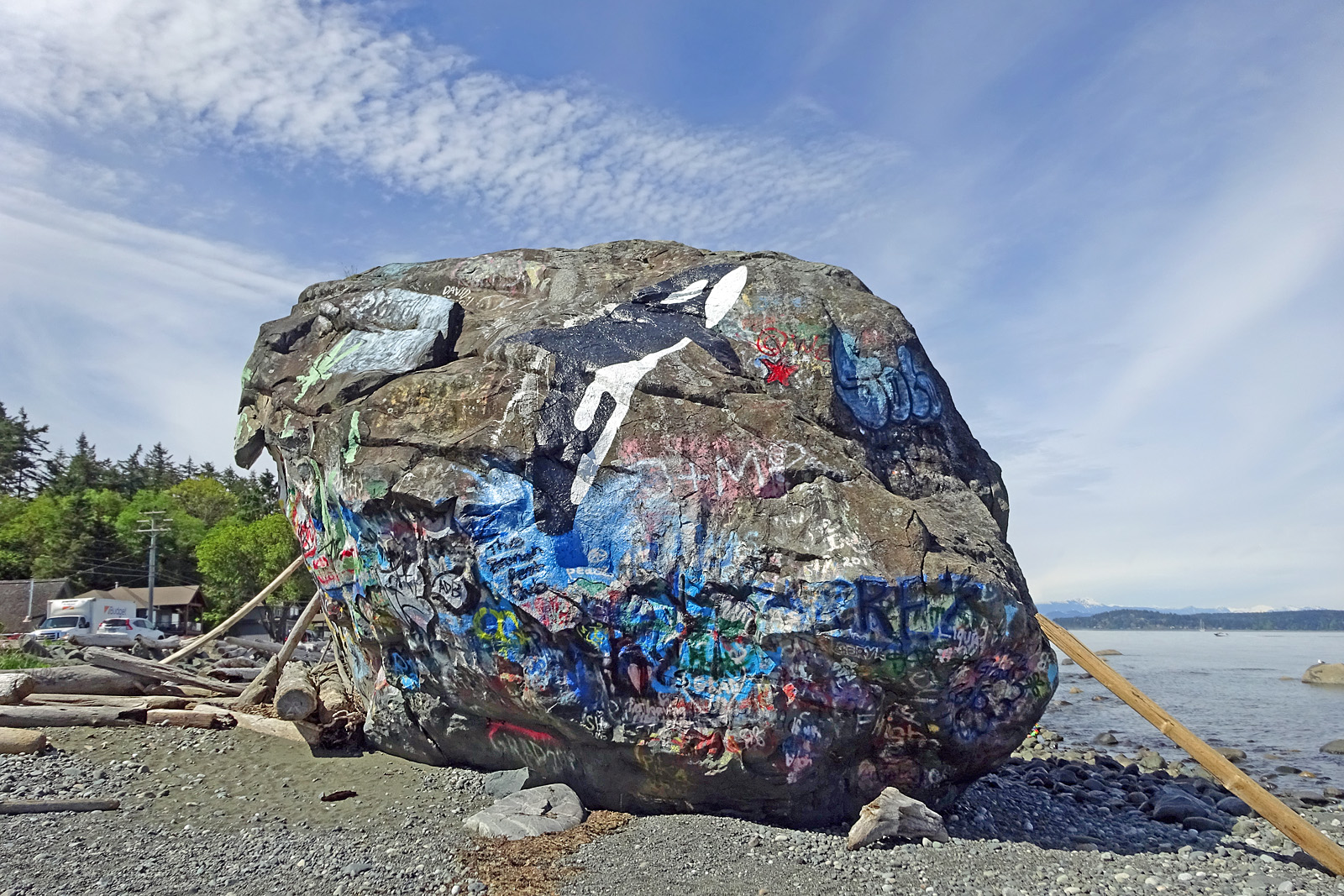
We call it Big Rock. Of course; the first thing we notice about it is its size: huge. It sits at the top of the beach, looming. 10 metres high, and wider than it is tall; it probably weighs around 8000 tons.

The south face. The poles have been left by climbers and graffiti artists. Every so often, someone erects a driftwood sculpture on the top.

I have been driving by the rock several times a week for two years now, and had never stopped before to look at it properly until a couple of days ago. High time.

North face. Current graffiti includes a dragonfly and umpteen "We were here" messages.

Some 10 to 15 thousand years ago, most of Vancouver Island was weighed down by ice up to 2 kilometres thick, so heavy that it pushed the land down under the sea. And for those thousands of years, the ice collected rock and debris from the mountains and dragged or pushed it down towards the sea.

The ice melted finally, the land rose, and Big Rock was left stranded on the shore, probably hundreds of kilometres from its source. (A glacier moves about 30 cm. per day: calculate that over 1,000 years!) Geologists call these glacier leftovers "erratics".

Grass and moss growing on the inland top side.

A landmark so obvious is bound to collect legends. Some First Nations stories explain the rock as a grizzly that tried to jump over from Quadra Island and didn't make it; others say it's a beached whale, condemned to stand on the shore forever as punishment for swallowing a fisherman off Mitlenatch Island.

Graffiti comes and goes, but the painting of the whale is always renewed.

Lichen on the shoreward side, above the reach of salt water.

I had read that there is a benchmark embedded in the rock. I walked around the rock, searching carefully; on the third circuit, I found it, a metal plaque, about 3 inches across, half hidden under several layers of paint. (I tried to scrape off the red paint with a stone, and just exposed the blue underneath. I gave up.)

I can't read what it says. The horizontal line marks sea level.

(Now that I know where it is, I can see it in the second photo above; low down on the sunny side, near the logs, just under a white curve. All around the rock, the graffiti is faded below this line; it's underwater at high tide.)

Under a rock overhang, I found this perfectly preserved crane fly, in a skimpy spider's web. The sharply pointed tip of the abdomen identifies her as a female.


Sunday, October 21, 2007

Couldn't keep these to myself...

I was sorting out some 10-year-old photos for my youngest son, and I came across these, from the couple of summers that he went tree-planting in BC's north country.

I said I would upload them to Flickr, and his reply was, "Cool". So, given that they're now public, I must share them with you.

These are copies of copies: photos taken with my camera of old hard-copy photos from a cheap film camera. I don't know exactly where they were taken, just "up North".


Music


Ice and water


Waterfall


Glacier runoff


Warm afternoon

Tuesday, October 16, 2007

Sad comment

This is a photo from the Bella Coola trip that I posted on Flickr.


A glacier, unnamed, somewhere along the ferry route, melting into the valley below.

Two days ago, Nod 432 left a comment: "Take a good look 'cause these things are melting fast!"

So true. So sad.

I have noticed, in the years since I left, that every year's crop of photos of my beloved Nusatsum mountain shows more rock, less ice.

As it was, once.
(Government photo, from a defunct page)


Chester Fried Snootli, originally uploaded by Dru!.

Snootli Peak, also in the Bella Coola Valley. Barely a hint of ice on top now.

Today, browsing mountains in the area, I came across this ex-glacier.

(Image by Dru.)

Dru describes it thus:
This lake was a glacier until about 1985, when it started to break up as melt water accumulated. Now it's full of giant icebergs that you can see the layering from the original glacier in. It will probably take another 30 years to fully melt. Located off the Satsalla River valley on BC's central coast at an elevation of around 1800m.
What can I say? Will we get around to turning down the heat before our mountains are bare rock?

I'm not too hopeful.

Tuesday, June 26, 2007

A River Runs Through It

Bella Coola trip, Part IV: Layout

(Part I, Part II, Part III)

Long before we reached the Bella Coola valley, we could see the river. It mingled with the salt water of the ocean all the way down North Bentinck Arm and well into the Burke Channel, turning the current a milky pale green.

(See Google map.)

What turns it that colour is glacier melt. The Bella Coola River is a short one, as rivers go; less than 75 km from its start at Burnt Bridge to the tide flats in Bella Coola. But it is formed by the union of the Atnarko and the Tlachako rivers flowing down from the mountains, both glacier runoff. The glaciers, inching down the rock slopes, grind that rock into a fine powder. In the summer, when the glaciers are melting more quickly, the rivers and creeks of the valley run greenish white.
The tide flats, at high tide. Half river water, half salt.

One of the many creeks, Thorsen Creek, I think. Or Snootli.

The Bella Coola Valley is a favoured tourist destination. No Club Med, very little "entertainment", at least in the summertime; what it offers is scenery, fishing (some of the best in the world, they tell me), wildlife, hiking, historical and arqueological "points of interest" and even some mountain climbing.

The valley itself is about 75 km long, and only about a mile wide at the bottom; a crack in the Coastal Range between high mountains. Nusatsum* (7400 ft.), Mt. Saugstad, the Saloompt, Mt. Stupendous, Table Mountain, Mount Defiant and more; wherever you look, a high peak forms the backdrop.

At the eastern end, the road (there is only one) loses its pavement and crawls up to the plateau, some 2500 feet above, which is accomplished in a few short miles, some at an 18% grade. "The Hill" and the long, lonely drive back to civilization serve as a natural barrier. Most visitors fly or, now, take the ferry, as we did.

I had lived here (up-valley) for 8 years, long before I met Laurie; this was the first time we had made the trip together. There was much to show him.

First, just beyond the ferry landing, is the rock inscribed by Sir Alexander Mackenzie, arriving overland from the East coast in 1793. The end of his trail; from here he turned back because of the hostility of the Bella Bella natives, just down the Channel and perpetual rivals of the Bella Coolas. Hikers still follow his old trail up the valley and on to the volcanic Rainbows (8000 and more feet).

The Rock. Written by MacKenzie with bear grease and vermilion, later scratched in by surveyors.


My daughter's in-laws picked us up at the ferry and drove us to Hagensborg, half way up the valley. Here we would have a house to ourselves and the use of a car for the week. We would see everything!

Weather permitting, of course.Next post: Hagensborg church, Saloompt bridge, etc.
* My story: Nusatsum: A Parable.
Friday, June 22, 2007

Good Planets are Hard to Find, June Edition # 2

How cunningly nature hides every wrinkle of her inconceivable antiquity under roses and violets and morning dew! ~Ralph Waldo Emerson
Fragility and Durability; two sides of the same coin. The most transient, delicate butterfly emerges, flies and is gone, but she leaves behind a row of eggs; and conversely, the most solid, taken-for-granted, ancient ground under our feet will someday crumble.

Robin forwarded this photo, sent by Evan of Virginia; his newborn son. He writes:
"The doctors are still wiping the fluids off of him seconds after birth."
Congratulations, Evan! And long may he thrive!
A little girl comes to grips with impermanence.Bev, of Burning Silo, sends this tiny plume moth, possibly a Himmelman's PM.

And also from Bev, a pair of Delicate Cycnia moths, photographed at her farm this week.
Robin, at Dharma Bums, says,
"I saw this very sweet chickadee pulling fibers from our doormat again. She may be getting ready for her second brood. There is something about the black-capped chickadee that is the essence of cuteness. They are tiny, but have incredible presence."
And this one, from C. Corax, rouses all my protective instincts; a temporarily, I hope, blind garter snake.

She writes,
"When I saw this garter snake, I assumed she was getting ready to shed. But I wonder--perhaps someone knowledgeable about snakes can tell me for sure--whether the snake has actually shed already but is retaining the eye scales. She was very nervous at my approach. Certainly when a snake is blind, even temporarily, it is very vulnerable. If vulnerability is viewed as a sort of fragility, this photo fits the theme."

Yankee Transplant sends this New England reservoir, demonstrating "durability and variety from season to season."
Along the Kamloops - Merritt highway, this dead tree still serves as a handy roost for birds.
A glacier calving brings to mind the fragility of our planet and its climate. From Wrenaissance Woman.
Eggshell china, almost a century old: Japanese Kutani porcelain. So delicate you can see through it to the signature on the back, so sturdy it stands up to a lifetime of tea ceremonies. From Laurie's collection.
Detail of the saucer.
And the cup to go with it.

And also from Wrenaissance Woman,
"Denali, ... one of the sacred places of the earth. Its durability gives me hope that we, and our good planet, will survive the current mess we're making."

It's a Good Planet we have here, a splendid, breath-taking planet. Thanks to all for sending these amazing photos of it.

Next Good Planets will be hosted by SBGypsy, of The Gypsy's Caravan. You can e-mail your photos to sbgypsy AT hotmail DOT com, on or before the Friday after next.

See you over there!

Friday, June 01, 2007

A terrible, stark beauty

Sometimes I let my mouse do the walking. On Google maps.

A few days ago, I went north. To the far Canadian north, at the very edge of the satelite views.

These are not trees; they are rivers. With no vegetation to slow them, shield them from view, they become sharp-edged trunks and branches.

More "trees":
Flat mud plains. What looks, to my eyes, like ridges, are really indentations, small valleys. I can't seem to convince my brain of that, though, and I still see concave plains with upturned edges.
Jagged chunks of ice, at the mouth of a river. This one still has the scale at the bottom; it measures off 1 mile.
More ice, rugged valleys, sharp peaks. Impossible country. Imagine hiking over that!
The glaciers flow just like wet water, only more slowly.
I don't know what to say about this country. It fills me with a wordless awe, it humbles me more, even, than gazing into a starry sky does; it's closer to home, but somehow feels more terrible, colder, more alien. And yet I have rarely seen anything so beautiful.

It's not just these representative views; it was also the effect of wandering, mouse-walking, step by step over endless brown terrain, lifeless and silent. Except, of course, for the roar of waters, the crashing of rock, the ping! of splitting ice. And probably the howl of wind. But no birdsong, no whisper of pines. Screen after screen of ever-different sameness. It gives me the shivers, and not from the imagined cold.

Where are these sites? Here, at the markers.
(And don't forget to click on these for a full-size view.)
Powered By Blogger