Mud Bay is the inside tip of Boundary Bay. Here, a map might help:
Boundary Bay forms the southern shore of the Fraser Delta. From the tip of the Tsawwassen Peninsula, at Point Roberts (USA), to Kwomais Point across the water, it measures about 13 km. From that same tip to the inner shore, at Mud Bay Station, it's 17 km. (At low tide, it is considerably smaller.)
See that amphipod-like blue-green shape at the top of the bay? That's all mud. And at the interior end, where the Serpentine and the Nicomekl rivers drop silt from the farms of the Fraser Valley, is Mud Bay Station. Here the railway turns to skirt the shoreline on its way to the US, marching straight across a sea of mud to cut the corner. And this is our destination. There are walking and biking paths around the hawk fields, but we are looking for the mud dwellers on the shore.
Boundary Bay is a prime birding spot; Mud Bay may be the best part of it. On this visit, we saw large flocks of red-wing blackbirds (the females have arrived, and they're all singing and chattering at once as they sort out nesting spots among the dry grasses), several great blue herons, a cacophony or two of crows, and a couple of hawks. And that's all before we even got to the shore.
 |
| Grey mud, then grey and orange water with birdy sprinkles. Straight ahead, Crescent Beach. It's about 3 PM, but the sun is already low in the southwest. |
 |
| Most of our photos were silhouettes. These are long-billed dowitchers, and one green-winged teal. |
 |
| Green-winged teal, much lightened up. I hadn't seen one for years; this time, there were several large flocks. |
 |
| Long-billed dowitchers. Look closely; the one in front is pulling a worm out of the mud. The little tubes sticking up here and there are worms, too. |
 |
| Northern pintails, pairing up. The males have the long tail, and the white bib; the females are "normal" ducks. |
 |
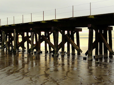
| The railroad trestle bridge across the bay. I liked the way the warm sunlight tinted the mud. |
By the way, that's deep stuff. I took one step wrong at the very edge of the rocks, and was immediately up to my ankle in mud. Laurie got stuck the same way for a while; I thought he was going to lose a boot.
On the far side of the tracks, in the dead end of the bay, another large, mixed flock of ducks swam in the river mouth, while dowitchers searched through the mud by the old, rotten fence. Looking closely at our photos, I noticed that most of the pintails sit upright, head high. Almost all the teals in the photos are lying flat, often with their faces in the water.
We usually see gulls and eagles here; only one eagle this time.
 |
| Calm before sunset. |
 |
| Laurie waiting for me. I was taking photos of coconuts. |
A Skywatch post.


Neat photos.
ReplyDeleteAmazing colors! So soft and gentle :)
ReplyDeleteAwesome shots!! Thanks for sharing!
ReplyDeleteSky Watch
I read yesterday's post this morning, and started doing a search for mud bay station, but found nothing...then your post this morning explained it all. I've driven past countless times, and have wanted to find a way down there, but I'm never able to find a place to pull off the highway. Now, looking at the map, I know where it is and how to get there, thanks!
ReplyDeleteNice photos S - I really miss the Lower Mainland birding and mud flat exploration!
ReplyDelete