 |
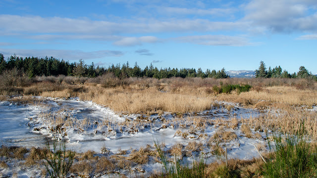
| View over the southeast end of the marsh, looking northeast. The hills beyond are on the mainland. |
There is a sign beside the road; I stopped to read it.
 |
| Description of the restoration program. |
The sign reads: Environmentally Sensitive Fish Habitat. Discovery Harbour Shopping Centre Ltd, developed and managed by the Campbell River Indian Band and Northwest Properties in conjunction with Federal Fisheries and Oceans and the Canadian Wildlife Service conducted a low marsh restoration and planting program in the Campbell River Estuary within Lot 136 and Spit Road in 1997 and 1999. As part of the estuary restoration plan, relocation of Old Spit Road occurred and natural estuary was re-established. Designed by TERA Planning Ltd, the planting was completed by members of the Campbell River Indian Band.
(This whole area had been used for logging operations, heavy equipment and other industrial uses for most of the last century. Now, it is being restored, piece by piece.)
Continuing with the text of the sign: To assist the natural recolonization of the estuary area, salvaged vegetative material was stockpiled for use. Approximately 800 sq m of plant material, including Lyngbye's and other sedges, spikerush, hairgrass and other low marsh species were removed and stored in a donor site. The existing slough was not touched.
(Me again. I'd never heard of these wetlands species. I looked them up. Lyngbye's sedge is "often the most dominant species in tidal marshes ..." [Plants of Coastal BC] "This is a pioneer species, one of the first plants to colonize the mud of tidal flats in its range. [Wikipedia]
Spikerush is not a rush, but a creeping wetland sedge. Hairgrass would be the tufted hairgrass, Deschampsia cespitosa; it is a native perennial grass about a metre tall. Some of the photos I took of the ice look like the base is this grass.)
Back to the sign: The eastern half of the program was conducted in the spring of 1997 and the culverts at Old Spit Road were opened at that time. This included the removal of shrub vegetation and soil, followed by the establishment of a network of channels planted with approximately 400 sq m of the stockpiled vegetation (or 20,000 15 cm x 15 cm cylinders of marsh material.)
A lot of work! The shrub vegetation removed would have included the invasive Himalayan blackberry: there is still a heavy infestation in the area between this wetland and the river bank.
 |
| Photos from the sign |
The western half and the area under the Old Spit Road were replanted in early 1999. Construction was similar to that done for the eastern half. This phase saw the decommissioning of Old Spit Road itself. This project has created approximately 2 ha of low marsh. The new marsh is now an important contributor of fish nutrients and provides rearing habitat for your salmon.
I went looking for this old road last year. I found the end of it, but it petered out in a few metres. It's bird, bug, and fish habitat now. And maybe chocolate lily habitat, but I'll have to forgo looking for them.
 |
| Under the roof of the above sign. Juvenile salmon live here!! |
 |
| Google map of the area, with my labels. |

No comments:
Post a Comment
I'm having to moderate all comments because Blogger seems to have a problem notifying me. Sorry about that. I will review them several times daily, though, until this issue is fixed.
Also, I have word verification on, because I found out that not only do I get spam without it, but it gets passed on to anyone commenting in that thread. Not cool!