Showing posts with label estuary. Show all posts

Monday, July 05, 2021

Exposed

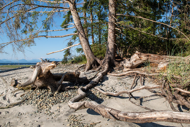
Amazing tree roots:

At the edge of Black Creek, half creek bed, half intertidal zone, all the soil has washed away, exposing wandering roots.

Black Creek estuary. Miracle Beach starts to the right.

~~~~~~~~~~~~~~~~~~~~~~
Raices impresionantes: a la orilla del riachuelo "Black", donde sube la marea, el agua, llegando y yéndose, se ha llevado la tierra y la materia vegetal, dejando solamente arena fina. Y las raices de un árbol, expuestos al aire. Raices bien largas, por cierto.

Segunda foto: el estuario del riachuelo. Hacia la derecha empieza la playa "Milagro".


Tuesday, March 16, 2021

Last of the pre-spring colours.

Browns and blues along the Myrt Thompson Trail.

North shore, from the first bridge to the islets.

Up-river from this point, it's mostly fresh water. Here, the tide brings in salt, and there are barnacles growing on the rocks under the bridge.

A hint of red, as the alder catkins start to bloom.

The final island (no bridge to this) and the opening to the Narrows and Quadra Island on the far side.

A Skywatch post.

~~~~~~~~~~~~~~~~~~~

Los colores: azul y café, desde el sendero Myrt Thompson.

Primera foto: la vista desde el primer puente, y la ribera al norte. Río arriba de este punto, el agua es fresca, sin sal; agua del río. Pero hasta aquí llega la marea, y debajo del puente bálanos crecen en las rocas.

Segunda foto: sigue el sendero. Hay una tinta de rojo, ya que las inflorencias masculinas (candelillas) están empezando a abrirse.

Tercera foto: vista hacia la boca del río, con la última isla, esta sin puente, y la apertura al Estrecho, con la isla Quadra en el fondo.

Es un post para Skywatch. Haz clik en el enlace para ver cielos alrededor del mundo de esta semana.


Tuesday, January 28, 2020

The brown lands

The Campbell River rushes down towards the sea from John Hart Lake, knowing where it's going, and not wasting time sightseeing. But then it hits the flats, and loses all sense of direction, wandering about, making side trips, back-tracking, stopping at interesting corners, following a sleepy duck or a browsing raccoon, making circles around little islands, carving out a lagoon or two, checking out interesting tree roots ...

It gets there, eventually, but in the meantime it has created a wild, muddy, grassy maze, green in the spring and summer, brown all winter.

The end of the estuary, from the Myrt Thompson trail. The fence protects recently re-planted native vegetation.

Sign near this veiwpoint, with old map of the estuary.

Text of sign: Estuaries form where rivers meet the sea.
Rivers slow as they flow through coastal floodlands and out into the Pacific Ocean. Silts and nutrients settle to form fertile delta soils, mud and sand banks and various marsh habitats. The diverse specially adapted marsh plant communities and wide flat intertidal areas are exposed twice a day by the tides and are teeming with tiny worms, snails, and crustaceans.
These are the most biologically diverse wetlands along the Pacific coast. They provide ideal feeding and resting areas for millions of waterfowl, shorebirds, wintering birds of prey, salmon stocks and many other life forms. They are essential to the survival of hundreds of fish and wildlife species, and the people relying on them.

Y en español:
Tierras pardas.

El Rio Campbell corre hacia el mar desde el Lago John Hart, sin perder el tiempo dando vueltas, como que sabe bien para donde va. Luego llega a las tierras planas y pierde toda idea de urgencia y se pone a dar vueltas, regresar a mirar alguna esquina interesante, seguir el rastro de un pato dormilón o de un mapache en busca de cangrejos de río, hacer círculos alrededor de una islita, colarse bajo las raíces de los árboles, descansar en una laguna perdida ...

Llega al mar, al fin, pero en camino ha formado un laberinto lodoso, lleno de plantas semi-marítimas y pastos, inhóspito para los humanos, pero un paraíso para los pájaros, verde en primavera y verano, y de una variedad de colores café en el invierno.

En la primera foto, se ve el estuario desde una península a medio rio. Las redes protegen plantas nativas recién sembradas.

La segunda foto es de un anuncio cerca del camino.

Dice: Los estuarios forman donde los ríos llegan al mar.
Los ríos corren lentamente através de tierras inundables y salen al Oceano Pacífico. Allí en la delta, cienos y materias nutritivas se depositan y forman tierras fértiles, bancos de lodo y de arena, y pantanos de varios tipos. Las comunidades de plantas pantanales adaptadas especialmente a estas condiciones, y las áreas planas litorales se exponen al aire dos veces diarias por las mareas, y abundan en gusanos, caracoles, y crustáceos.
Estos son los terrenos humedales con más variedad biológica en la costa del Pacífico. Proveen areas ideales donde millones de pájaros acuáticas y playeras, aves de rapiña que pasan aquí el invierno, salmones y muchos otros animales descansan y se alimentan. Son esenciales para la sobrevivencia de cientos de especies de pescado y otros animales salvajes, y de la personas que de ellos dependen.


Friday, January 15, 2016

Trail to Serendip

If I'd been paying attention, I never would have found it. I daydreamed myself into the wrong lane, got hemmed in by trucks, and was forced to turn right down a side street that, two blocks later, dead-ended at the river bank.

Campbell River, looking down towards the estuary.

I parked and went to look at the river. On my left, a wood fence shut off the view and access to the bank. On the right, blackberry canes and other weedy shrubs made another wall of sorts. But while I watched the river, a woman with a hiking stick and a backpack came along behind me and turned into a narrow gap in that wall. I followed her.

There was a path, narrow and muddy, hemmed in by weeds, but after a short walk, it broke through into an open space. There were benches, and a sign.

Myrt Thompson Trail. Home Depot off to the right.

The trail itself hadn't been improved; it remained narrow, half gravel, half mud, carved out only by foot traffic. I went on; the trail had to lead somewhere.

It follows the river bank, heading downstream, towards the estuary, an area that I had often looked at from Tyee Spit, but never found any way to get there. Now, in mid-winter, the vegetation is mainly weedy grass and, along the bank, alders and evergreens. Someone has planted a few new evergreens alongside the path; they look like they're struggling through their first winter.

The trail goes on and on, past old parking lots, (Where did those come from? Where is the access? Not on Google maps, for sure.) across a narrow wood bridge, onto a long spit barely a dozen metres across, with the trail down the centre. I met a few people; crossing a bridge, I had to press up tight against the side to allow them to pass.

Eagle landing. I think that's a crow on the tip of the tree on the right.

Red and yellow branches beside a bridge. Waiting for spring.

A narrow spit with a flock of sleeping mallards.

Nearer the river mouth, the water breaks up into a maze of back-channels, pools, and bays; mini-islands dot the area. In the main channel of the river, the current is strong, but here, the water lies quiet. Ducks dabble in the shallows or sleep in the sunshine. Overhead, high in the trees, eagles squeak, their calls sounding more like reluctant doors than like bird song. In the distance, I saw an osprey.

With the sun behind a hill, looking towards the town behind yet another islet. It's cold, and each house sends up its plume of smoke; I can smell wood burning, even from here.

After a time, the trail ends in a wood observation platform, looking across the estuary to Tyee Spit and the ocean beyond. But no, the trail hasn't ended, except in the planners' minds; the footpath takes off to the right, through a stand of alder, down a spit as narrow as the mallards' bedroom, to the very tip.

The river opens into the sea. Tyee Spit lies directly ahead, with the airplane hangars and offices on the right. On the left, industry on the far bank of the river.

I turned and went back. I still had errands to run before dark.

Moss between the path and the river, with afternoon shadows.

Near the beginning of the trail, an explanatory sign has been erected. Now, muddy and scratched, it is difficult to read. I took a photo and cleaned it up enough to decipher the information.

Part of the sign.

It tells of the restoration of Baikie Island, which had been an industrial site until recently; the area around it is still full of machinery and noise. At home, I looked it up on the web; it's not marked on Google maps; on the map version, not even the access road to Baikie Island is included. But I found some information on the Campbell River Parks site.

Baikie Island is the bit of land I had been watching across the river from the path I was on. I had poked around that area, and found no access to the shore, but it must be there, though there are no signs that I could find. (Like the unmarked Myrt Thompson Trail that I was on.)

Google maps. The Campbell River estuary. I have marked the MT Trail in red. It's a little over 1 km long. Baikie Island is the leaf-shaped land mass in the bay to the left.

The next day that the weather permits, I'll head over there and find the entrance.

A pair of eagles on a tree on Baikie Island.


Powered By Blogger