Showing posts with label Western bog-laurel. Show all posts

Tuesday, June 17, 2025

These flowers have pockets

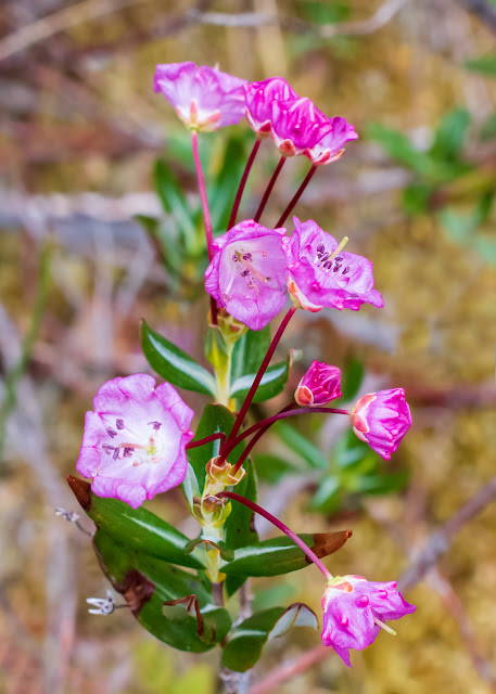
I have dropped in to Sundew Bog, by the shore of Upper Campbell Lake, twice recently. In the first visit, the third week of May, the bog-laurels were in full flower; a week later, most of these flowers were gone. 

Western Bog-laurel, Kalmia microphylla ssp. occidentalis. The buds look like miniature jewellery boxes.

As the box opens, the pouches around the edge hold their shape.

Fully opened flowers still retain those pockets.

And the fruits; round capsules with the long style persisting.

The flower has "10 stamens, the tip of each tucked into a small pouch in a petal, and held under tension as a bow; at the slightest touch by an insect probing for nectar, the stamens pop out and dust the insect with pollen." (Plants of Coastal British Columbia)

Looking at the third photo above, you can see one flower where the stamens are still held in these pouches. The rest of the flowers have already scattered their pollen.

~~~~~~~~~~~~~~~~~~

He visitado el Pantano de Rocíos de Sol, dos veces en el último mes. La primera vez, en la tercera semana de mayo, los laureles de pantano estaban cubiertos de flores. Una semana más tarde, casi todas las flores habían desaparecido. Son plantas de temperaturas frias.
  1.  Laurel de pantano, Kalmia microphylla ssp. occidentalis. Los botones parecen pequeñas cajas para joyería.
  2. Flores medio abiertas. Las protuberancias alrededor de la flor permanecen intactas.
  3. Las flores completamente abiertas. Las protuberancias, vistas desde el centro de la flor, parecen bolsitas.
  4. Y las frutas; globos que retienen el pistilo de la flor.
La flor tiene "10 estambres, la punta de cada uno insertada dentro de una pequeña bolsa en un pétalo, donde se mantiene bajo tensión como si fuera un arco (para tirar flechas); con el contacto mínimo con un insecto buscando el néctar, los estambres se liberan y cubren el insecto con polen." (Plants of Coastal British Columbia)
Mirando la tercera foto arriba, se puede notar que en una flor los estambres todavía permanecen dentro de las bolsitas. Las demás flores ya han esparcido su polen.


Tuesday, June 11, 2024

Still wandering in Sundew Bog

The plants in Sundew Bog (beside Upper Campbell Lake) grow in three distinct layers. First, the nose-to-the-ground level, the yellowish sphagnum mosses, the sundews that give the fen its name, the tiny bog cranberries. 

Get up off your knees and meet the middle layer. These are shrubs, knee- to waist-high. The bog-laurels, with their pink flowers in May, the Labrador tea, filling the fen with white flowers in June. Buckbeans, here and there a skunk cabbage, in a deeper puddle, a starter group of water lilies.

Stand tall and look up: there are a few trees, a snag or two. A smidgen of shade over a bench on the central platform. A handful of young evergreens. Mostly, though, there's open sky.

This week, the bog-laurel has produced its tiny, inedible fruit.

Kalmia microphylla ssp. occidentalis.

Strange fruits: tiny red capsules, with the flower's pistil still present at the top, looking like a continuation of the stem, as if the fruits were beads strung on a red string. 

In wetter, open areas, the buckbeans are waving their short stalks with three leaves to a stalk. A few, too far away to see clearly, are in flower.
 
Frilly buckbean flowers, Menyanthes trifoliata.

The tallest of the trees, too tall to get it all in without leaving the boardwalk. Lichen replaces the needles it once held.

Hemlock cones, above the observation post.

~~~~~~~~~~~~~~
Las plantas que observamos en la Ciénaga de Rocíos del Sol (al lado del lago Upper Campbell) crecen en tres niveles. Primero, con tu nariz casi en el suelo, ves los musgos esfagnos, y las plantas carnívoras que dan el nombre al sitio, y los arándanos de pantano, tan pequeñitos.

Estabas de rodillas. Ahora, párate para ver las plantas del nivel mediano, a la altura de tus rodillas hasta la cintura. Arbustos como la Kalmia microphyla, con sus flores color de rosa en mayo, el thé de Labrador, que ahora llena todo con sus flores blancas. Hay tréboles de agua, Menyanthes trifoliata; una que otra col de los pantanos; y en un charco algo profundo, unos lirios de agua.

Ahora levanta la cabeza. Cielo abierto, pero con unos cuantos árboles, tantos muertos como vivos. Un poco de sombra sobre uno de los asientos en la plataforma de observación. Algunos arbolitos juveniles de hoja perenne. 
  1. Esta semana, la Kalmia microphylla ha producido sus frutas pequeñas, no comestibles. Tienen una forma rara; un tallo rojo, luego la fruta, redonda como una canica, y luego el pistilo de la flor, como si fuera una extensión del tallo, como si la fruta fuera una perla roja ensartada en un hilo rojo,
  2. Tréboles de agua; cada tallo lleva tres hojas. Algunos, pero muy lejos, ya estaban en flor. Las flores son blancas con detalles en rosa, y con volantes en los pétalos.
  3. El árbol más alto. Ya muerto, con líquenes sustituyendo a las hojas.
  4. Una rama de un Tsuga sp., con sus piñas. Este árbol es el que nos dió un poquito de sombra donde nos sentamos a descansar.

Wednesday, May 08, 2024

Bog or fen? Which is it?

 Continuing with Sundew Bog.

First, some flowers:

Western bog-laurel, Kalmia microphylla.

Intriguing flowers: look at the buds at the top right. They're little pink boxes, with a star-shaped lid. Next, the lid opens to form a squarish bowl with a starburst decoration at the bottom. The fully-open flower is paler, softer, more rounded.

A sign tells me to look for Labrador tea, but it's too early; it blooms in late May or June.

Another view of the bog: 

The boardwalk bounces on that soggy, mossy ground as you walk.

And, let's look at that sign:

What's that? Non-forested fen?

Text:
The non-forested fen wetland ecosystem is a shrub-dominated, nutrient-medium peatland ecosystem. Fens are the most common wetland in the province and are an intermediate ecosystem between a marsh and a bog ecosystem.
Fens develop in basins, seepage slopes, or protected lake or pond margins where permanently saturated soil conditions are present and recieve nutrient and water inputs from groundwater.
Organic soils support a large complement of plant species, dominated by sedges and a well-developed moss layer (brown and sphagnum {peat} mosses), red-osier dogwood, sweet gale, Pacific ninebark, and evergreen dwarf shrubs.
Fens support aquatic insect populations, such as dragonflies, who rely on wetlands for breeding and early life stages. The peatland ecosystem can support unique arthropods. Rodents such as shrews, mice, and voles will use fens extensively, waterbirds use fens for nesting, listen for the frogs!
Ok, this is confusing. They're calling it a bog at the entrance and on the map, and now it's a fen, not a bog (second sentence above). Which is it? What do these words mean?

Searching the web added to the confusion, at first; there are conflicting, sometimes opposite definitions, and often the two words are used interchangeably. But there are a few clear explanations:

First: Wetlands: "Wetlands are areas where water covers the soil, or is present either at or near the surface of the soil all year or for varying periods of time during the year, including during the growing season." (US EPA)

Bogs and fens (and marshes and sloughs and swamps ...) are specific types of wetlands.

A bog is a freshwater wetland of soft, spongy ground consisting mainly of partially decayed plant matter called peat. (NatGeo) Fens have less peat and more plant life than a bog.  A bog typically is watered by rainfall, whereas a fen arises from groundwater; "because fens are supplied with mineral-rich water, they tend to range from slightly acidic to slightly basic, while bogs are always acidic because precipitation lacks the dissolved minerals (e.g. calcium, magnesium, carbonate) that act to buffer the natural acidity of atmospheric carbon dioxide." (Wikipedia) "A fen is characterized by still ponds below ground level, a bog by little streams and small pools." (Quora)  A marsh is a tract of low, wet, soft land that is temporarily, or permanently, covered with water, characterized by aquatic, grasslike vegetation.

In the Canadian Wetland Classification System, fens are defined by six characteristics:
1. Peat is present.
2. The surface of the wetland is level with the water table. Water flows on the surface and through the subsurface of the wetland.
3.The water table fluctuates. It may be at the surface of the wetland or a few centimeters above or below it.
4.The wetland receives a significant amount of its water from mineral-rich groundwater or surface water.
5.Decomposed sedges or brown moss peat are present.
6.The vegetation is predominantly graminoids (grass-like plants) and shrubs.
Whereas Wikipedia's definition of a bog includes:
The wetland receives most of its water and nutrients from precipitation (ombrotrophic {cloud-fed}) rather than surface or groundwater.

Hey, all this is good for my eyes; now I see what otherwise I would have missed. And I found a nice, new word, ombrotrophic!

~~~~~~~~~~~

Seguimos con la Ciénaga de Rocíos del Sol:

Fotos:

  1. Primero, las flores. Estas son  Kalmia microphylla. Míralas bien; el botón es como una cajita con su tapa en forma de estrella. Al empezar a abrirse, se desdobla la tapa, formando un recipiente con lados verticales y con una estrella en el fondo. Y luego, las flores abiertas pierden todos esos ángulos.
  2. Otra vista del sitio. El paseo de madera brinca sobre el terreno al caminar.
  3. Y uno de los letreros, este informándonos sobre "Los pantanos sin bosque".
El texto del letrero dice:

El ecosistema del humedal pantanoso sin bosque es una turbera dominada por arbustos, proveyendo un promedio mediano de nutrientes. Los pantanos son el tipo de humedal más comunes en la provincia (Columbia Británica) y constituyen un ecosistema intermedio entre un marjal y una ciénaga.
Los pantanos se desarrollan en depresiones, pendientes con filtración de agua, o en los márgenes protegidos de lagos y lagunas donde el suelo permanece saturado y donde recibe ingresos de agua y nutrientes de las aguas subterráneas.
Los suelos orgánicos sostienen una gran variedad de especies de plantas, principalmente los ciperáceos y una capa bien desarrollada de musgos (musgos cafés y musgos de turbera, o esfagnos), Cornus sericea, mirto de turbera (Myrica gale), Physocarpus capitatus, y arbustos enanos perennes.
Los pantanos sostienen poblaciones de insectos acuáticos, tales como las libélulas, las cuales dependen de los humedales durante la temporada de cría y las primeras etapas de la vida. El sistema de las turberas puede sostener algunos artrópodos singulares. Roedores como las musarañas (Sorex sp. y otros) y los ratones dependen en gran parte de los pantanos, y aves acuáticas hacen aquí sus nidos. ¡Y escucha! ¿Puedes oir el canto de las ranas?
Bueno, ésto me deja algo confusa. En el letrero en la entrada, y en el mapa, lo llaman una ciénaga, y ahora resulta que es un pantano. (Mira el final del párrafo primero arriba.) ¿Pues, qué es? ¿Un pantano o una ciénaga? ¿Qué quieren decir estas palabras?

Al buscar definiciones, al principio, me quedaba igualmente sin entender, pero por fin hallé unas definiciones claras.

Estos terrenos son humedales. 
El humedal es cualquier área que permanece en condiciones de inundación o con suelo saturado con agua durante períodos considerables de tiempo. Entre ellos, los pantanos son zonas abiertas y aireadas, como una pradera, cubiertas de hierbas acuáticas y plantas como los juncos (Juncus sp.) y las ciperáceos (Carex sp.). Las ciénagas (cieno = logo suave) son bosques húmedos dominados por árboles y arbustos.El marjal es tierra plana, generalmente costera, sumergida en agua de escasa profundidad. (Selecciones
Las ciénagas y los pantanos son turberas; la turba es la acumulación de material orgánico muerto de hojas, tallos y raíces parcialmente descompuestos de diversos musgos y otras plantas que se han acumulado en un ambiente saturado con agua en ausencia de oxígeno. El pantano contiene menos turba y más vegetación que la ciénaga. Porque la ciénaga recibe su agua de la lluvia, mientras que el pantano la recibe de aguas subterráneas, bien mineralizadas, el agua de los pantanos tiende hacia lo básico, mientras que el agua de la ciénaga es acídica. 
Según el Sistema de Clasificación de Humedales Canadiense, los pantanos muestran 6 características, entre ellas:

2. La superficie del humedal está al nivel del agua subterránea. Agua fluye encima de la superficie y debajo de la superficie.
4.El humedal recibe una cantidad importante de su agua de parte de aguas subterráneas o agua de la superficie, aguas ricas en minerales.
Mientras que la definción de una ciénaga, según Wikipedia incluye:
El humedal recibe la mayor parte de su agua y sus nutrientes de la lluvia y nieve, en lugar de las aguas subterráneas o de la superficie. (ombrotróficas {alimentadas desde las nubes}

Powered By Blogger