Showing posts with label US/Canada border. Show all posts

Thursday, July 02, 2015

Hope your Canada Day ...

... was as good as mine!

The tide was low near noon again, and the sun was scorching. I joined the streams of people heading out to the border marker in the middle of Boundary Bay. I didn't quite make it; the water was still a bit out of my depth, carrying a dry-land camera. But I plowed through eelgrass beds, thigh-deep, until the tide was at its lowest, then returned to the marker.

Where I met Tim, who blogs at Think Big - No, Even Bigger. He had come out to see how the starfish are doing, and incidentally, to see if I was there. Once he'd made it to the marker and taken a few photos with his underwater camera (see his post on TBNEB, with video), he walked back with me to the shore a kilometre away.

He has sharp eyes; he saw a big anemone in the shadow of the eelgrasses, where all I could see was a dark splotch. It was anchored on an empty clamshell, so I brought it home and settled it in the tank. It seems happy enough.

Plumose anemone, Metridium senile

Standing tall, about three inches. Fully grown, it can reach well over twice that.

These anemones come in a variety of colours, from white to yellow to orange or brown. Wikipedia adds pink, grey and olive green, which I don't remember ever seeing. Tim has photos from the border marker, underwater; the ones there are pure white, pale beige, green, or a deep, reddish brown. (Go look.)

As usual, there were hitchhikers. I'll tell you about these later on. After I've finished with the photos of the drenched ten-lined June beetle.

And thanks, Tim!


Tuesday, June 23, 2015

Purple starfish! Healthy purple starfish!

I've found about a dozen of the purple starfish, the ones most affected by the sea star wasting syndrome. And they look healthy!

The way it worked out was this: on the most recent trip to the low tide line, when I found all those six-armed and mottled stars, I waded as close as I could to the border marker. Couldn't get quite there; the water would have been up to my waist, and I wasn't dressed for that.

But I stopped there to take photos of an eagle, and then a pair of eagles perched on the top of the marker.

One eagle

Two eagles. He seems to be doing some sort of dance.

They sang a duet for a while, him squealing and her burbling, while I tried to find solid footing underwater to get a good shot. I gave up and backed off, to take a photo of the whole marker with the reflections in the water.

Striped zones: watermarks, bare cement, barnacles, and a layer of seaweed, then the shelf. Then the whole thing reverses in the water.

At home, I had other photos to sort, and too much to do; the eagles got set aside and forgotten. It wasn't until tonight, cleaning up the recent files, that I saw the starfish.

Do you see them? Look on the right-hand end of the shelf for a pile, and then scan left.

From here, they look healthy enough; properly spread out, wearing all their arms. There's even at least one young one, just under the ladder.

This makes me happy.

As I trudged back towards the distant shore, one of the eagles passed me, in a hurry.

Things to do, errands to run, chocolates (or fish) to get for her ...


Thursday, April 18, 2013

Boat at mid-tide

Boundary Bay, as the tide comes in . . .

Looking southeast, towards the US border marker at the edge of the intertidal zone, from somewhere near the middle. The tideflats go out almost a mile here.


A Skywatch post

Sunday, May 09, 2010

Black Oystercatcher

We ventured down to Point Roberts for the day. If it were not for the long wait at the border, going both ways (half an hour going south into the US, about 15 minutes coming home; very slow, for a small crossing), we would plan on visiting often. Next time, we'll go on a weekday; the line-up may be shorter.

Point Roberts is a small spit of land, a snippet cut off from Canada and allocated to the US, because of inadequate mapping before the boundary was agreed upon. The line across the continent goes straight from the Great Lakes to the Georgia Strait, where it bends to leave all of Vancouver Island inside Canada. It wasn't until this was ratified that the Tsawwassen area was surveyed, when it was discovered that the very tip was below the line. This has produced some odd effects; for example, school buses take children from Point Roberts to school in Blaine, crossing the border twice enroute.

It's sparsely populated; the lots are enormous, and there is room to breathe between clusters of homes. Most of the population in the summer are Canadians. In winter, there are fewer than a couple of thousand residents. On the southwest, the land is bare and flat, sloping down to a clean, stony beach; there's forest on the east, cut off from the sea by tall sandstone cliffs. (The geology is interesting; see Wikipedia.)

It's the first time we've been there on our own, so we followed our noses, taking whatever turn appealed to us, exploring, ending up skirting the coastline from the marina to Maple Beach, across the street from our usual parking spot in Canada, and back to customs along the border, looking at all our landmarks from the backside.

The tide was in, but we spent an hour on the beach, watching birds and boats, and the blue, blue horizon. A flock of surf scoters dived in unison, coming up again all together in a close circle. This is the first time I've seen that behaviour; most diving ducks come up singly.

We saw, from a distance, a flock of dark ducks with white underparts at the rear. In flight, they flashed a startling white V at the tail. I haven't been able to identify them; any hints?


Rear view


And turned around, facing us.

*Update: in the comments, Amie Roman identifies them as Brant geese. Thanks, Amie!

And this topped off the day; a lifer! Oystercatchers.


"Peep!" A loud "PEEP", not the shy "peep" of the yellowlegs and sandpipers.

Black heads, dark brown bodies, pinkish legs, big feet. And those amazing beaks; long and heavy-looking, and a fiery red. The eyes are yellow, with a red ring around them; jet lag eyes. They poked among the rocks just at water's edge. I didn't see them find anything, but they eat limpets, mussels and clams. And oysters, of course.


Standing on one leg, warming the other toes.

A minute or two after they flew away, a small flock of sandpipers rose up from the same area, and sped away, "peep, peep, peep"-ing as they went. We hadn't even seen them, we had been so engrossed watching the oystercatchers.

We'll be back; we want to see those cliffs from the shore side again, and we will eventually visit the marina. If the border crossing isn't too bad on the cliff excursion, that is.

Sunday, May 02, 2010

Measuring the horizon

Low tide this week has been really low. Friday afternoon, off Crescent Beach, it was down to 2 feet. And we arrived at the beach across the bay in Tsawwassen just a half-hour before the turn. It looked, then, as if the sand went on forever, or at least till it met the Crescent Beach sand coming the other way.


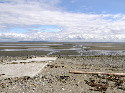
Sand and sky

This photo is from the boat launching runway at Beach Grove, just a block north of the US/Canada border. The black dot 'way over on the horizon, towards the right, is the mid-channel border marker. The low rise on the right side is Crescent Beach hill.

Appearances are deceiving; Crescent Beach is 7 1//2 miles across the bay. The border marker is a mere 3/5 of a mile from this point. Between the beaches, then, there are some 6 miles of open water.


Looking north, towards Surrey. Also about 7  miles distant, but without the open water between. It's sand, then mud. Miles of slushy, deep mud.

I decided to hurry out and see if I could reach the border marker before the tide stopped me. I rolled up my pant legs (we weren't dressed for the beach; we'd come to Tsawwassen for the annual Delta Potters' sale) and got moving. Laurie had the wrong shoes; he went more slowly, looking at crabs and seaweed.


Almost there. Only two more sandbars to go.

I almost made it. At the last "river", I stopped. The water was up to my knees, getting deeper with each step, and I wasn't sure exactly when the tide would turn; it races in, here, and I could be trapped. I can swim, but the camera can't.

I could see, though, that after that last sandbar, the water suddenly became very dark; it was even deeper, too deep to wade those last few feet, even if I trusted the tide.

The last stream went along a thick eelgrass bed; I was wading blind, with the grass tickling my legs. I stepped on what I thought was a rock, and nearly lost my balance. I kicked it out of the way. But it didn't feel "rockish"; more like a large clam shell. Then it ran over my foot. A crab, and a big one.

My toes were bare. I got out of there.


Looking north, from the eelgrass bed. The hills of Delta, straight ahead, Tsawwassen to the left.


From Laurie's wanderings, more to the north. Looking straight south to the tip of Point Roberts, 2 miles away, across the border. The hills are at least 15, probably 20 miles south.


A shallow eelgrass bed, barely mid-calf deep.

The water was still receding slowly when I joined Laurie back on the sandbars, but a few minutes later, it changed direction, dragging the eelgrass with it. Time to head for shore.

A Skywatch post.
Powered By Blogger